
Keywords: ice conditions, ice cover of the seas, ice thickness, power of the icebreaker, safety of the navigation, sum of the degree-days of frost
Years of discussions regarding usefulness of long-term forecasts, and the lack of their acceptance by our foreign colleagues haven’t yet convinced Roshydromet to abandon the practice of making long-term forecasts. Long-term forecasts of AARI and Hydrometcentre of Russia are used in FGI (Federal Government Institution) ‘The Administration of the Northern Sea Route’ and FSUE (Federal State Unitary Enterprise) ‘Rosmorport’ for planning of icebreakers operation areas during the summer navigation in the Arctic and winter navigation in non-Arctic seas. The main practical task of long-term ice forecasting is to inform the maritime community about prospective severity of ice conditions in a certain sea. These conditions are supposed to be easy (E), moderate (M) or difficult (D).
The term ‘difficult ice conditions’ is subjective and implies not only a certain geographic latitude and power of icebreaker fleet, but also the particular climate characteristics in which navigators are accustomed to operate. Shippping companies have changed significantly their definition of ‘difficult ice conditions’ over the past decade. On several occasions (e.g. in January, 2008 and in March, 2020) the experts of the Ministry of Transport of the Russian Federation (Mintrans of Russia ) consulted with Roshydromet on whether the ice conditions in the Sea of Azov were extremely difficult for navigation. In fact, in January, 2008 about 150 vessels awaited for icebreaker assistance near the ice edge, though by winter classification by sum of degree-days of frost (DDF), the winter of 2007/2008 (as well as the winter of 2011/2012) in the Sea of Azov was determined as moderate winter according to climatic stereotype of 20th century, while severe winter in the Sea of Azov is characterized by fast ice thicknesses of 45-60 cm [3].
Similar problems have occurred in the Gulf of Finland where severe winter (according to stereotype of 20th century) hadn’t been observed for already 30 years (the last severe winter was in 1986/1987). During the navigation of 2010-2011 (‘moderate winter’) vessels were assisted by 10 icebreakers, however, due to the difficult ice situation, nuclear icebreaker ‘Vaygach’ had to be sent to the Gulf of Finland for the first time in the history. Icebreaker support was required to assist oil supertankers from Primorsk. Nuclear icebreakers assistance in the Gulf of Finland took place also in 2012 (nuclear icebreakers ‘Rossiya’ and ’50 Let Pobedy’) and in 2013 (nuclear icebreaker ‘Rossiya’).
This paper aims to determine the relevance of technical characteristics of icebreaker fleet in the different seas of Russia to sea ice conditions not only for the modern period of global warming but also for the most severe winters observed in 20th century.
1. Data on hydrometeorological conditions and icebreaker fleet status
Table 1 contains information about time-series of environmental characteristics used for analysis of easy, moderate and difficult ice conditions in different seas.
Table 1 – Time series of environmental characteristics
|
Sea |
Sea region or observation station |
Characteristics |
Observation period |
Observation period, years |
|
Kara Sea |
Dikson Island |
DDF |
1921-2018 |
98 |
|
FT |
1926-2018 |
93 |
||
|
White Sea |
Arkhangelsk |
DDF |
1813-2018 |
206 |
|
Mudyug Island |
FT |
1914-2018 |
105 |
|
|
Baltic Sea |
St.Petersburg |
DDF |
1811-2018 |
208 |
|
Kronstadt |
FT |
1911-2018 |
108 |
|
|
Vyborg |
FT |
1930-2018 |
89 |
|
|
Sea of Azov |
Rostov-on-Don |
DDF |
1882-2018 |
137 |
|
Taganrog |
FT |
1924-2018 |
95 |
|
|
Caspian Sea |
Astrakhan |
DDF |
1846-2018 |
173 |
|
Bol’shoy Peshnoy Island |
FT |
1930-2018 |
89 |
|
|
Iskustvenniy Island - Lagan |
FT |
1953-2018 |
66 |
|
|
Bering Sea |
Anadyr |
DDF |
1916-2018 |
103 |
|
FT |
1963-2018 |
56 |
||
|
Sea of Okhotsk |
Magadan |
DDF |
1933-2018 |
86 |
|
FT |
1933-1994 |
65 |
||
|
Poronaysk |
DDF |
1909-2018 |
110 |
|
|
Ayan |
FT |
1934-2018 |
85 |
|
|
Sea of Japan |
Aleksandrovsk-Sakhalinskiy |
DDF |
1891-2018 |
128 |
|
FT |
1953-2018 |
66 |
The paper often refers to a vessel class, therefore Table 2 contains characteristics of ice classes of icebreakers and vessels.
Table 3 contains permissible marine operations and the corresponding ice conditions in the Arctic seas and the severe non-Arctic Bering Sea.
Table 4 contains established restrictions for navigation in non-Arctic harbor areas.
Table 2 – Characteristics of ice classes of icebreakers and vessels
|
Ice class |
Characteristics of icebreaking operations permitted |
Total power, kW |
|
Icebreaker, LL1 |
In the Arctic seas (AS) on coastal routes and shore ice belt routes in high latitude all year round. Capable of forcing the way in compact ice field over 2.0 m thick. |
≥47807 |
|
Icebreaker, LL2 |
In the AS during the summer period and for operation on coastal routes during the winter period. Capable of forcing the way in compact ice field less than 2.0 m thick. |
22065 - 47807 |
|
Icebreaker, LL3 |
In shallow waters and mouths of rivers flowing into the Arctic seas during the winter period without assistance as well as for operation on coastal routes in the Arctic seas under convoy of icebreakers of higher category. Capable of forcing the way in compact ice field up to 1.5 m thick. |
11032-22065 |
|
Icebreaker, LL4 |
In harbor and roadstead water areas without assistance all the year round as well as for operations in the non-Arctic freezing seas (NAS) under convoy of icebreakers of higher category during the winter period. Capable of forcing the way in compact ice field up to 1.0 m thick. |
< 11032 |
|
Vessel, Arc 9 |
In AS in close ice up to 3.5 m thick during winter-spring navigation and up to 4.0 m thick during summer-autumn navigation |
- |
|
Vessel, Arc 8 |
In AS in close ice up to 2.1 m thick during winter-spring navigation and up to 3.1 m thick during summer-autumn navigation; in navigable passage astern an icebreaker in ice up to 3.4 m thick during winter-spring and summer-autumn navigation. |
- |
|
Vessel, Arc 7 |
In AS in close ice up to 1.4 m thick during winter-spring navigation and up to 1.7 m thick during summer-autumn navigation; in navigable passage astern an icebreaker in ice up to 2.0 m thick during winter-spring navigation and up to 3.2 m thick during summer-autumn navigation. |
- |
|
Vessel, Arc 6 |
In AS in open ice up to 1.1 m thick during winter-spring navigation and up to 1.3 m thick during summer-autumn navigation; in navigable passage astern an icebreaker in ice up to 1.2 m thick during winter-spring navigation and up to 1.7 m thick during summer-autumn navigation. |
- |
|
Vessel, Arc 5 |
In AS in open ice up to 0.8 m thick during winter-spring navigation and up to 1.0 m thick during summer-autumn navigation; in navigable passage astern an icebreaker in ice up to 0.9 m thick during winter-spring navigation and up to 1.2 m thick during summer-autumn navigation. |
- |
|
Vessel, Arc 4 |
In AS in open ice up to 0.6 m thick during winter-spring navigation and up to 0.8 m thick during summer-autumn navigation; in navigable passage astern an icebreaker in ice up to 0.7 m thick during winter-spring navigation and up to 1.0 m thick during summer-autumn navigation. |
- |
|
Vessel, Ice 3 |
Independent navigation open brush ice in NAS and in compact ice up to 0.7 m thick in navigable passage astern an icebreaker |
- |
|
Vessel, Ice 2 |
Independent navigation in open brush ice in NAS and in compact ice up to 0.55 m thick in navigable passage astern an icebreaker |
- |
|
Vessel, Ice 1 |
Independent occasional navigation in open brush ice in NAS and in compact ice up to 0.4 m thick in navigable passage astern an icebreaker |
- |
|
Vessel, UL |
Independent navigation in AS during summer and autumn in easy ice conditions; all-year round in NAS |
- |
|
Vessel, ULA |
Independent navigation everywhere in the World Ocean during summer and autumn |
- |
Table 3 - Restrictions for different ice classes to navigate in the Arctic seas and in the Bering Sea
|
Type of ice conditions |
Description of ice conditions |
Ice class of vessels |
|
|
independent navigation |
navigation under icebreaker assistance |
||
|
Easy |
New, young and thin first-year ice (up to 0.7 m thick), appearance and presence of medium first-year ice (less than 1.2 m thick) up to 25% |
Arc 4 or higher ice class |
Arc 4 or higher ice class |
|
Moderate |
Medium first-year ice (up to 1.2 m thick) in amount of 25% and more, which may include thick first-year ice (more than 1.2.m thick) inclusions up to 25% |
Arc 7 or higher ice class |
Arc 6 or higher ice class |
|
Difficult |
Thick first-year ice (more than 1.2 m thick) and multi-year ice (more than 2 m thick) in amount of at least 25% |
Arc 8-Arc-9 |
Arc 7 or higher ice class |
Table 4 – Restrictions for different ice classes to navigate in non-Arctic seas
|
Type of ice conditions |
Ice cover thickness |
Ice class of vessels |
|||
|
Northern seas |
Southern seas |
independent navigation |
navigation under icebreaker assistance |
not allowed for navigation |
|
|
Easy |
Easy |
10-15 cm |
Ice 1 or higher ice class |
Vessels without ice strengthening |
Tugs and tows |
|
Moderate |
Moderate |
15-30 cm |
Ice 2 or higher ice class |
Ice 1 |
Vessels without ice class, tugs and tows |
|
Moderate |
Difficult |
30-50 cm |
Ice 3 or higher ice class |
Ice 1 and Ice 2 |
Vessels without ice class, tugs and tows |
|
Difficult |
Extremely difficult |
>50 cm |
Arc 4 or higher ice class |
Ice 2 and Ice 3 |
Vessels without ice class or Ice 1, tugs and tows |
Note: Northern seas here are the White Sea, the Gulf of Finland, seas of Far-East; southern seas here are the Sea of Azov and the Caspian Sea.
Table 4 shows:
- Ice-strengthened vessels Arc 6 are allowed to navigate independently in easy ice conditions and with icebreaker assistance in moderate ice conditions;
- Ice-strengthened vessels Arc 7 are allowed to navigate independently in moderate ice conditions and with icebreaker assistance in difficult ice conditions;
- Ice-strengthened vessels Arc 8 and Arc 9 are allowed to navigate independently in all types of ice conditions.
Comparison of Table 3 and Table 4 shows that similar ice conditions are considered as easy in the Arctic seas and in the Bering Sea, and extremely difficult in the Sea of Azov and the Caspian Sea.
‘Easy’ and ‘difficult’ ice conditions vary in the southern and the northern seas. Characteristics of ice-going vessels and the power of icebreaker fleet in different seas vary considerably. Historically association of icebreakers and vessels operating in specific sea is based on the moderate ice conditions in this sea. Table 5 represents real operating areas of icebreakers in the Russian seas approved by the Mintrans for the period of 2017-2018, and calculated average power of icebreakers (shaft power or propeller power for pod driven icebreakers).
Table 5 – Operating areas of icebreakers and icebreaking vessels in 2017-2018, approved by the Mintrans for icebreaker assistance in the freezing ports of Russia.
|
Sea, region |
Operating area |
Icebreaker, tugboat |
Power, kW |
Average power, kW |
|
|
routes |
ports |
||||
|
Kara Sea |
Kara Sea, Port of Sabetta |
NIB ’50 Let Pobedy’ |
49000 |
40750 |
16000 |
|
Kara Sea, Port of Sabetta |
NIB ‘Yamal’ |
49000 |
|||
|
Gulf of Ob (Ob Bay), Port of Sabetta |
NIB ‘Vaygach’ |
32500 |
|||
|
Yenisey Gulf |
NIB ‘Taymyr’ |
32500 |
|||
|
Sabetta port area |
IB ‘Moskva’ |
16000 |
|||
|
White Sea |
Sea, route |
IB ‘Dikson’ |
7000 |
16750 |
3200 |
|
Sea, route |
IB ‘Admiral Makarov’ |
26500 |
|||
|
Ports of Arkhangelsk, Severodvinsk, Onega |
IB ‘Kapitan Evdokimov’ |
3800 |
|||
|
Ports of Arkhangelsk and Kandalaksha |
IB ‘Kapitan Kosolapov’ |
2500 |
|||
|
Ports of Arkhangelsk and Onega |
IB ‘Kapitan Chadaev’ |
3300 |
|||
|
Gulf of Finland |
The gulf, route |
IB ‘Kapitan Sorokin’ |
16200 |
18480 |
3970 |
|
The gulf, route |
IB ‘Ermak’ |
26500 |
|||
|
The gulf, route |
IB ‘Murmansk’ |
18000 |
|||
|
The gulf, route |
IB ‘Kapitan Nikolaev’ |
16200 |
|||
|
The gulf, route |
IB ‘Novorossiysk’ |
18000 |
|||
|
The gulf, route |
IB ‘Sankt Peterburg’ |
16000 |
|||
|
Port of St. Petersburg |
IB ‘Mudyug’ |
7000 |
|||
|
Port of St. Petersburg |
IB ‘Semen Dezhnev’ |
3450 |
|||
|
Port of St. Petersburg |
IB ‘Ivan Kruzenshtern’ |
3900 |
|||
|
Ust-Luga Sea Port |
IB ‘Karu’ |
4160 |
|||
|
Ust-Luga Sea Port |
IB ‘Kapitan Plakhin’ |
3300 |
|||
|
Ports of Vyborg and Vysotsk |
IB ‘Kapitan M.Izmaylov’ |
2500 |
|||
|
Ports of Vyborg and Vysotsk |
IB ‘Yuriy Lisyanskiy’ |
3500 |
|||
|
Sea of Azov |
Sea, route |
IB ‘Kapitan Moshkin’ |
3800 |
3600 |
1180 |
|
Sea, route |
IB ‘Kapitan Demidov’ |
3800 |
|||
|
Sea, route |
IB ‘Kapitan Chudinov’ |
3800 |
|||
|
Sea, route |
IB ‘Kapitan Zarubin’ |
3300 |
|||
|
Sea, route |
IB ‘Kapitan Krutov’ |
3300 |
|||
|
Port of Taganrog |
T/IB ‘Kama’ |
1660 |
|||
|
Ports of Azov and Rostov-on-Don |
T/IB ‘Kapitan Kharchikov’ |
1660 |
|||
|
Ports of Azov and Rostov-on-Don |
‘Fanagoriya’ |
544 |
|||
|
Port of Yeysk |
‘Tekhflotets’ |
1180 |
|||
|
Port of Yeysk |
‘Kolguyev’ |
860 |
|||
|
Caspian Sea |
Sea, Ports of Olya, Astrakhan |
IB ‘Kapitan Chechkin’ |
3300 |
3470 |
3470 |
|
Sea, Ports of Olya, Astrakhan |
IB ‘Kapitan Bukaev’ |
3300 |
|||
|
Sea, Ports of Olya, Astrakhan |
IB ‘Kapitan Metsayk’ |
3800 |
|||
|
Sea of Okhotsk |
Sea, route, Port of Magadan |
IB ‘Magadan’ |
7000 |
11600 |
11600 |
|
Sea, route, Prigorodnoye Sea Port |
IB ‘Kapitan Khlebnikov’ |
16200 |
|||
|
Strait of Tartary |
Strait, route |
IB ‘Krasin’ |
26500 |
1610 |
3320 |
|
Strait, route, Port of Vanino |
MPSV ‘Spasatel Kavdejkin’ |
5760 |
|||
|
Port of Vanino |
T ‘Khasanets’ |
884 |
|||
|
Peter the Great Gulf |
Gulf, Port of Vladivostok |
T ‘Viktor Muhortov’ |
883 |
1490 |
1490 |
|
Gulf, Vostochny Port |
T ‘Olimp’ |
1910 |
|||
|
Gulf, Port of Olga |
T ‘Barkhat 1’ |
600 |
|||
|
Gulf, Port of Posyet |
T ‘Khasan’ |
2029 |
|||
|
Gulf, Port of Posyet |
T ‘Aleut’ |
2029 |
|||
Note: NIB – nuclear-powered icebreaker, IB – icebreaker, T – tugboat, MPSV - multipurpose salvage vessel
2. Principles of classification of ice conditions into easy, moderate and difficult in the Arctic and non-Arctic seas
According to the researches in the non-Arctic seas mild winters correspond to easy ice conditions, moderate winters correspond to moderate ice conditions, severe winters correspond to difficult ice conditions [1]. Classification of winters by sum of degree-days of frost is usual and has proved to be well in characterizing ice conditions in different seas. The eminent expert in ice navigation theory, particularly in icebreaking capability in the Arctic and non-Arctic seas, Gordiyenko P.A. used this approach as basic in his papers [9-11]. For his research on icebreaking capability, Gordiyenko looked at the movement through ice of various thickness of the diesel icebreaker ‘Moskva’ built in 1960 and possessing significant, for that period, propeller power of 16000 kW (with total power 19000 kW). Five new diesel icebreakers coming into commission in 2008-2016 (with the lead icebreaker of the series ‘Moskva’) have total power 21000-27840 kW.
Recently the power of icebreakers has increased; furthermore, global climate is warming. Thus it is important not only to study whether it is enough to use sum of degree-days of frost to characterize different types of ice conditions, but also to determine whether the power of icebreaker fleet of a particular sea corresponds to observed ice conditions, and to understand what does ‘difficult ice conditions’ mean in this particular case.
‘Difficult’ ice conditions in the Gulf of Finland are only a relative term considering the modern state of the icebreaker fleet, for example, of the Northern-West basin Subsidiary of Rosmorport. The main reason of involving nuclear icebreaking fleet to the Gulf of Finland was not the severity of winters but necessity of providing broad waterways for supertankers.
Nevertheless, the probability of actually severe winters like those described in unique observational materials on ice cover of 20th century, still exists. Data on ice conditions during the most severe winters of the entire period of observation, which corresponds to the most difficult ice conditions, is of great practical value.
Designers of hydraulic structures and icebreakers base their calculations on extreme winter data. Thus, to estimate possible ice loads on the bridge pillars during the construction of the Kerch Strait Bridge, ice thickness in Taman, which was observed during the most extreme winter on the Sea of Azov in 1954 (64 cm), was used.
Moreover, engineers enhance the power of nuclear icebreakers using information on extreme ice conditions in the Arctic region, which was observed in 1950-1990. Designed icebreaking capability of the most powerful up to date nuclear icebreakers ’50 Let Pobedy’ and ‘Yamal’ is 2.2-2.9 m (real value – 2.25 m). In 2012 AO ‘Baltic Shipyard’ started building a lead ship of the new class of icebreakers – project 22220 (LK-60Ya). The ships of the class have beam of 34 m, which is 4 meters wider than their predecessors, the ‘Arctica’ class icebreakers. It is essential for assisting large cargo ships. Moreover, the icebreaker of new class is able to combine function of deep-draft icebreaker for operating in the Central Arctic, and shallow-draft icebreaker working in the mouths of Siberian Rivers. This dual-draft icebreaker takes aboard 9000 tons of ballast water and changes its draft form 10.5 to 8.5 meters by the discharge of ballast water. The power of this class of ships is up to 60000 kW. The first ship of this class having legendary name ‘Arktika’ is expected to come into service in 2020, the next are expected to come into service nuclear-powered icebreakers ‘Sibir’ (in 2021) and ‘Ural’ (in 2022). At present, the construction of new project of nuclear icebreaker ‘Lider’ with power of 120000 kW, the beam of 47.7 m and designed icebreaking capability of 4.3 m is under discussion. This is the plan of Russian shipbuilders who enhance the guaranteed reliability of navigation in any ice conditions every decade. However, it would be good to observe balance between a desire to obtain funding for construction new super-icebreakers and real necessity of building such icebreakers.
Long practice of hydrometeorological and ice services of navigation in the non-Arctic seas during the cold periods shows that downward bias of average sum of degree-days of frost of specific ice season may cause problems for ice navigation in any seas.
The basis of dividing ice conditions in the Arctic seas into easy, moderate and difficult has been elaborated in AARI for many years. The expansion of industrialization of the North, longer navigation period, as well as an expected increase of cargo traffic in the Arctic by several times already to the 2024, require to specify types of ice conditions.
The peculiarity of winter ice conditions in the Arctic is the presence of residual ice in the beginning of new ice formation. During the ice seasons of 1960-1980s this factor as well as the cooling level (characterized by sum of degree-days of frost) affected the difficulty of ice conditions of the forthcoming and also the next-year ice seasons. The main underlying principle of the classification is unambiguous identification of ice conditions in the Arctic as easy, moderate or difficult.
There is no identification of easy, moderate or difficult ice conditions in the normative documents of Rosmorrechflot (Federal Agency for Sea and Inland Water Transport of the Russian Federation) and Roshydromet. Few documents contain directives on permission for vessels to navigate the Northern Sea Route (NSR) in various ice conditions [8] and averaged information on permissible navigation areas and ice navigation conditions [7]. Valuable data for identification of easy, moderate or difficult ice conditions were accumulated during winter navigation of vessels by ‘Norilsk Nickel’ in the south-western part of the Kara Sea and in the Yenisei Gulf.
Linear relations between DDF and some ice characteristics are studied to analyze the possibility of using the sum of degree-days of frost (DDF) as a single parameter to identify the type of ice conditions in different seas. Table 6 represents these relations.
Table 6 –Correlation between sum of degree-days of frost (DDF) and ice characteristics in 7 non-Arctic seas
|
Sea, sea region |
Relation between parameters: |
Linear function |
K |
|
Kara Sea |
DDF in Dickson and Hmax in the area of station Dickson |
0.0301*DDF+29.7 |
0.72 |
|
DDF in Dickson and Lmax in the Kara Sea |
0.0172*DDF-50.4 |
0.55 |
|
|
White Sea |
DDF in Arkhangelsk and Hmax in the area of station Mudyug |
0.0276*DDF+31.1 |
0.70 |
|
DDF in Arkhangelsk and Lmax in the Funnel of the White Sea |
0.0223*DDF+50.4 |
0.61 |
|
|
Baltic Sea |
DDF in St.Petersburg and Hmax in the area of station Kronstadt |
0.0321*DDF+29.9 |
0.76 |
|
DDF in St.Petersburg and Hmax in the area of station Viborg |
0.0296*DDF+33.2 |
0.72 |
|
|
DDF in St.Petersburg snd Lmax in the Gulf of Finland |
0.0696*DDF+36.2 |
0.78 |
|
|
DDF in St.Petersburg snd Lmax in the Baltic Sea |
0.0683*DDF+0.1 |
0.87 |
|
|
Sea of Azov |
DDF in Ristiv-on-Don and Hmax in the area of station Taganrog |
0.0589*DDF+11.7 |
0.86 |
|
DDF in Ristov-on Don and Lmax in the Sea of Azov |
0.1116*DDF+30.4 |
0.76 |
|
|
Caspian Sea |
DDF in Astrakhan and Hmax in the area of station Peshnoy |
0.0589*DDF+11.7 |
0.86 |
|
DDF in Astrakhan and Hmax in the area of station Iskustvenniy Island |
0.0449*DDF+7.5 |
0.84 |
|
|
DDF in Astrakhan and Lmax in the North of the Caspian Sea |
0.0347*DDF+65.3 |
0.77 |
|
|
Bering Sea |
DDF in Anadyr and Hmax in the area of station Anadyr |
0.0356*DDF+3.2 |
0.75 |
|
DDF in Anadyr and Lmax in the Bering Sea |
0.0088*DDF+5.5 |
0.62 |
|
|
Sea of Okhotsk |
DDF in Magadan and Hmax in the area of station Ayan |
0.0473*DDF+4.2 |
0.68 |
|
DDF in Magadan and Lmax in the Sea of Okhotsk |
0.0298*DDF+6.6 |
0.68 |
|
|
DDF in Poronaysk and Lmax in the Sea of Okhotsk |
0.0428*DDF+3.5 |
0.74 |
|
|
Average DDF in Poronaysk and Magadan and Lmax in the Sea of Okhotsk |
00.0421*DDF-8.5 |
0.77 |
|
|
Sea of Japan, Strait of Tartary |
DDF in Aleksandrovsk-Sakhalinskiy and Hmax in the area of station Aleksandrovsk-Sakhalinskiy |
0.0473*DDF+4.2 |
0.68 |
|
DDF in Aleksandrovsk-Sakhalinskiy and Lmax in the Strait of Tartary |
0.0298*DDF+6.6 |
0.68 |
Note: Hmax – maximum ice thickness for the ice season(cm); Lmax – maximum ice coverage during the ice season (%); K – correlation coefficient between calculated and observed characteristics.
Table 7 provides averaged quantitative information on permissible ice thickness at which vessel is able to navigate astern an icebreaker in open passage with low speed (2-5 knots) without increasing risk of damage due to interaction between ice and the hull. Table 8 provides information on permissible speed of vessel to navigate independently in different ice conditions.
Table 7 – Ice class of vessel and corresponding permissible ice thickness for navigation with icebreaker assistance
|
Ice class |
Ice age, Ice thickness, m |
|
|
Winter-spring navigation |
Summer-autumn navigation |
|
|
Arc 4 |
Thin first-year ice, up to 0.7 m |
Medium first-year ice, up to 0.9 m |
|
Arc 5 |
Medium first-year ice, up to 0.8 m |
Medium first-year ice, up to 1.2 m |
|
Arc 6 |
Medium first-year ice, up to 1.2 m |
Thick first-year ice, up to 1.5 m |
|
Arc 7 |
Thick first-year ice, up to 1.8 m |
Multi-year ice, up to 3.2 m |
|
Arc 8 |
Multi-year ice, up to 3.2 m |
Multi-year ice, up to 3.4 m |
|
Arc 9 |
Multi-year ice, up to 3.5 m |
Multi-year ice, more than 3.5 m |
Table 8 – Permissible speed (Vp) for independent navigation of different ice classes in various ice conditions
|
Ice class |
Vp., knots |
Ice concentration, tenths |
Ice age |
Ice thickness, m |
|
|
Winter-spring navigation |
Summer-autumn navigation |
||||
|
Arc 4 |
6-8 |
1-6/10 |
First-year ice |
0.6 |
0.8 |
|
Arc 5 |
« |
1-6/10 |
First-year ice |
0.8 |
1.0 |
|
Arc 6 |
« |
1-6/10 |
First-year ice |
1.1 |
1.3 |
|
Arc 7 |
« |
7-8/10 |
First-year ice |
1.4 |
1.7 |
|
Arc 8 |
10 |
7-8/10 |
Multi-year ice |
2.1 |
3.0 |
|
Arc 9 |
12 |
9-10/10 |
Multi-year ice |
3.5 |
4.0 |
Data listed above shows that guiding limit of ice thickness for independent navigation of ice-strengthened vessels Arc 4-Arc 6 with permissible speed up to 6-8 knots (easy ice conditions) is 0.6-1.1 m with partial concentration of first-year ice up to 6 tenths. Various speed, ice thickness and partial concentration of ice of different age may give various combinations of speed-thickness-concentration, however, permissible ice thickness is the determining factor for vessels.
Taking into account the principle of strict selection of criteria for classification, easy ice conditions for vessel classes Arc 4-Arc 6 and particularly Arc 7-Arc 9 are those with predominance of new ice, young ice and thin first-year ice (up to 0.7 m).
Using the same approach, the limits of moderate ice conditions, which allow navigation with icebreaker assistance for ice-strengthened vessels Arc 6 and independent navigation for ice-strengthened vessels Arc 7, are ice thicknesses up to 1.2 and up to 1.4 m, respectively.
Taking into account the principle of strict selection of criteria for classification, moderate ice conditions for ice-strengthened vessels Arc 6-Arc 7 and stronger classes (Arc 7-Arc 9) are those with predominance of first-year ice (ice thickness up to 1.2 m).
Difficult ice conditions, which allow navigation without restrictions for vessel classes Arc 8-Arc 9 and with restrictions for vessel class Arc 7, are those with thick first-year ice and old ice (ice thickness more than 1.2 m).
These limits coincide with ice age categories, which are identified on the Arctic sea-ice maps by international and national symbols of nomenclature of sea ice. Thus, determining the ice age is a standard procedure that doesn’t make any problem for captains and navigators of icebreakers and ice vessels.
However, it should be considered that transformation of thin first-year ice to medium and subsequently to thick first-year ice can lasts from 10 to 40-50 days. The beginning of a thicker ice type formation doesn’t mean univocal change of type of ice conditions as it reduces subsequently the period of navigation. Establishing the fact of older ice age type must be determined reliably by satellite images and shipboard observations. The experience of icebreaker assistance and support of navigation shows that navigation should be continued till there is a possibility to avoid unfavorable ice by maneuvering.
The experience of navigation and statistical calculations demonstrate that a vessel is able to avoid of unfavorable ice with partial concentration of 1-2 tenths by moving and maneuvering. It is substantially more difficult to avoid unfavorable ice with partial concentration more than 2-3 tenths, and it is totally impossible with 4-5 tenths.
All mentioned above allows to extend the limits for chosen criteria of determination of the type of ice conditions. But it should be considered that the accuracy of interpretation of satellite images and determining of ice age and ice cover boundary is about ±1 tenths. Therefore it is suggested to establish 3 tenths (30% from total amount of all ice types) as a limit of permissible presence of unfavorable ice. This approach ensures the presence of unfavorable ice in case of mistake of interpretation (which occurred rarely) not more than 4 tenths (40%) from the total ice concentration, i.e. the level of concentration when it is impossible to avoid unfavorable ice.
In the south-western part of the Kara Sea fast ice forms a narrow belt along the coastline in shallow waters and thus is not significance for navigation. Therefore it is suggested to exclude it from considering ice age categories.
In the north-eastern part of the sea fast ice formation all along the western passages to the Vilkitskiy Strait is possible. Fast ice there is an area of dynamic navigation and thus it is essential to consider its composition.
Considering the above it is suggested to establish the following criteria (i.e. limiting values) to determine type of ice conditions in the Kara Sea for winter season.
Easy ice conditions - new, young and thin first-year ice (up to 0.7 m) is observed, the presence of medium first-year ice up to 30% (Sav < 30%) is possible;
Moderate ice conditions – medium first-year ice (up to 1.2 m thick) is observed in amount of 30% and more (Sm ≥ 30%), the presence of thick first-year ice up to 30% (Sth<30%) is possible;
Difficult ice conditions – thick first-year ice (more than 1.2 m thick) and old ice are observed in amount not less than 30% (Sth ≥30%).
During the winter-spring seasons first-year ice of autumn formation prevails in the Arctic sea routes in conditions of global warming of the 21th century, thus it is worthwhile to correlate ice types and sum of degree-days of frost the same way it was made above for the non-Arctic seas. Table 9 shows results calculated by function from Table 6 for ice thickness (H, cm) and sum of degree-days of frost (DDF) in the area of station Dikson (correlation coefficient K=0.72).
Equation of converse relation is:
DDF=33.2*H-987
Table 9 – Ice class and corresponding permissible ice thickness for winter-spring navigation
|
Ice class |
Ice age, Ice thickness, cm |
DDF, ˚C |
|
Arc4 |
Thin first-year ice, up to 70 cm |
<1340 |
|
Arc5 |
Medium first-year ice, up to 80 cm |
<1670 |
|
Arc6 |
Medium first-year ice, up to 120 cm |
<2300 |
|
Arc7 |
Thick first-year ice, up to 180 cm |
<4990 |
|
Arc8 |
Multi-year ice, more than 200 cm |
<5650 |
|
Arc9 |
Multi-year ice, more than 200 cm |
<5650 |
Note: maximum observed DDF in the area of the Dickson Island was 5800˚C (in 1968/1969)
The experience of previous research [1] shows that relation between DDF and ice characteristics of non-Arctic seas are the same in the area of 600-700 km from the representative observation station. This statement is true for station Arkhangelsk (White Sea) with meridional extent of about 500 km; for station Rostov-on Don (Sea of Azov) with meridional extent of about 180 km; for station Astrakhan (northern Caspian Sea) with meridional extent of about 270 km; for station Aleksandrovsk-Sakhalinskiy (Strait of Tartary) with meridional extent of about 650 km.
Meridional extent of the Baltic Sea is 1200 km. The correlation coefficient between DDF in Saint-Petersburg and maximum ice cover in the Gulf of Finland is K=0.78. This relation is appropriate for the Gulf of Finland. However, the question is whether it is appropriate for the full area of the Baltic Sea. The area of interest is the northern part of the sea including the Gulf of Bothnia, which northern coastline is 700 km far from Saint-Petersburg.
To verify the relation for the full area of the Baltic Sea, the relation between DDF in Saint-Petersburg and maximum ice cover of the Baltic Sea is calculated using the data of FIMR (Finnish Institute of Marine). The correlation coefficient in this case is even stronger (K=0.87) in comparison with the correlation coefficient for the Gulf of Finland. Evidently it is because in our study we artificially limit the area of ice cover in the Gulf of Finland in the west, which makes the correlation weaker.
Meridional extent of the Bering Sea is about 1500 km, but ice covers usually the northern part of the sea. The longest ice route from Kresta Bay to the edge of ice cover is about 800 km. Sum of degree-days of frost is calculated using data of station Anadyr.
It should be taken into account that warm water masses of the Pacific Ocean affect the location of the edge of ice cover in the far-Eastern seas (thus, affect the ice cover) and thereby reduce the impact of DDF on ice cover. Correlation coefficient between DDF in Anadyr and maximum ice cover in the Bering Sea is K=0.62 and is considered as sufficient. Correlation coefficient between DDF and ice thickness in Anadyr is significant (K=0.76).
The Sea of Okhotsk covers an area of 1 583 000 km2, with meridional extent of 2200 km. Ice is observed in all regions of the sea. It is the most difficult sea to determine the ice conditions. The large extent of the sea causes the differences in temperature and ice regime in the northern, central and southern parts of the sea. Thus, extremely severe winter in the northern part of the Sea of Okhotsk was observed in 1965-1966, with abnormally low temperatures extended to the south to the latitude of the Shantar Islands; at the same time moderate winter was observed in the southern part of the sea. Typical situation during the severe winters in the central and southern parts of the Sea of Okhotsk is almost total covering by ice. Such situation was observed in 2001, with severe winter in the area from Bolshoy Shantar Island to Yuzhno-Kurilsk and, at the same time, moderate winter in the north of the Sea of Okhotsk (according to the data of Okhotsk and Magadan stations). In this case it is reasonable to divide the sea into two parts: northern part (northward of 54º N), and central-southern part (southward of 54º N). Calculations for the northern part of the Sea of Okhotsk are based on the data of station Magadan, calculations for the central-southern part are based on the data of station Poronaysk.
Table 10 provides information on the criteria of various ice conditions in the non-Arctic seas.
Table 10 – Criteria of different ice conditions in the non-Arctic seas
|
Sea, sea region |
Station |
Criteria based on DDF, °C |
||
|
Easy ice conditions (mild winter) |
Moderate ice conditions (moderate winter) |
Difficult ice conditions (severe winter) |
||
|
White Sea |
Arkhangelsk |
<1140 |
1140-1710 |
>1710 |
|
Baltic Sea, Gulf of Finland |
St.Petersburg |
<480 |
480-940 |
>940 |
|
Sea of Azov |
Rostov-on-Don |
<215 |
215-585 |
>585 |
|
Caspian Sea |
Astrakhan |
<265 |
265-640 |
>640 |
|
Bering Sea, Gulf of Anadyr |
Anadyr |
<3310 |
3310-3940 |
>3940 |
|
Sea of Okhotsk, northern part |
Magadan |
<2150 |
2150-2575 |
>2575 |
|
Sea of Okhotsk, mid-southern part |
Poronaysk |
<1530 |
1530-1960 |
>1960 |
|
Sea of Japan, Gulf of Tartary |
Aleksandrovsk-Sakhalinskiy |
<1635 |
1635-2015 |
>2015 |
3. Relation between sum of degree-days of frost and the power of icebreakers fleet in the Russian seas
It is possible to use the sum of degree-days of frost not only for specification of ice conditions. Linear relationship between DDF and the technical characteristics of icebreaker is useful for planning maritime operations.
Positive practical experience of using icebreakers to support winter navigation in the non-Arctic Russian seas and year-round navigation in the Arctic seas, as well, enables Mintrans of Russia to set the operating areas for icebreakers. The most powerful icebreakers operate in the Arctic, while low-powerful icebreaking vessels operate in non-Arctic southern seas.
Table 11 represents the correspondence of average icebreaker power in a certain sea to average DDF, average thickness of fast ice (Hf) and floating ice (Hfl) in the period of maximum ice development.
To evaluate ice conditions correctly it is important to learn the correlation between the thicknesses of fast and float ice. Karelin [4] analyzed data on ice thickness measurements during the drift of icebreaker ‘Lenin’ in 1937-1938 in the Arctic and compared them with fast ice thickness; thus in his research he concluded that ice thickness of smooth floating ice was 5-25% less than thickness of fast ice. Mironov in his researches [5, 6] shows that the difference between floating and fast ice thicknesses was 25-30% according to the observational data in the Laptev Sea in April-May 1988. In Table 11 the thickness of floating ice is calculated as 20% less than the thickness of fast ice.
Data from Table 11 (columns 4 and 6) enables to plot the relation between DDF and floating ice thicknesses in the Russian seas (Figure 1) with strong correlation (K=0.97).
Table 11 – Average power of icebreakers (Sav) and corresponding average ice characteristics
|
Sea, sea region |
Sav, kW |
Station (DDF/Hf) |
DDF, °C |
Hf, cm |
Hfl, cm |
|
1 |
2 |
3 |
4 |
5 |
6 |
|
Kara Sea |
40750 |
Dikson/Dikson |
4400 |
158 |
126 |
|
White Sea |
16750 |
Arkhangelsk/Mudyug Isl. |
1480 |
70 |
56 |
|
Baltic Sea, Gulf of Finland |
18480 |
St.Petersburg/Krondstast |
770 |
51 |
41 |
|
Sea of Azov |
3600 |
Rostov-on-Don/Taganrog |
400 |
37 |
30 |
|
Northern Caspian Sea |
3470 |
Astrakhan/Iskustvenniy Isl. |
460 |
28 |
22 |
|
Sea of Okhotsk, northern part |
11600 |
Magadan/Ayan |
2300 |
118 |
94 |
|
Sea of Japan, Gulf of Tartary |
1610 |
Aleksandrovsk-Sakhalinskiy/ Sovetskaya Gavan |
1790 |
100 |
80 |
|
Sea of Japan, Peter the Great Gulf |
1490 |
Vladivostok/Vladivistok |
1120 |
55 |
50 |
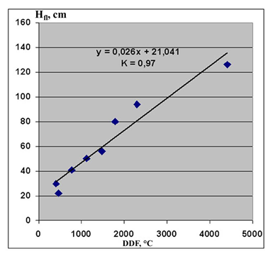
Figure 1 – Relationship between the thickness of floating ice and the sum of degree-days of frost.
Hfl=0.026·DDF +21 (1),
Hfl – average thickness of floating ice, cm
DDF – sum of degree-days of frost, °C.
Equation of converse relation:
DDF=36.023· Hfl-657 (2)
Data of Table 11 is also used to plot the relationship between average power of icebreakers and:
- thickness of floating ice corresponding with average ice conditions in various seas (Fig. 2a);
- average actual sum of degree-days of frost (Fig. 2b).
Icebreaker power which is required for different ice thicknesses, thus, is calculated using the relation:
Sav=254.5· Hfl-3655.7 (3),
Sav – average power of icebreaker, kW,
Hfl – average thickness of floating ice, cm.
Icebreaker power (Sav) for a particular sum of degree-days of frost is calculated using the relation:
Sav=8.071· DDF-614.2 (4).
Figure 2b shows the possibility of using air temperature data for evaluation of the required average power of the icebreaker fleet.
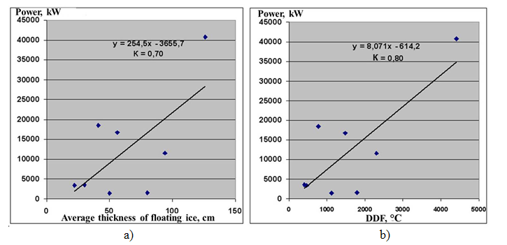
Figure 2 – Relationship between average power of
icebreaker and (a) floating ice thickness or (b) sum of degree-days of frost.
Table 12 provides data on designed icebreaking capability during the maritime operations in the Russian seas. Sum of degree-days of frost (column 7 of Table 12) corresponding with designed ice thickness is calculated by equation (2).
Table 12 – Designed icebreaking capability and corresponding sum of degree-days of frost
|
N |
Icebreaker |
Ice class |
Delivered power, kW |
Shaft power, kW |
Vo, knots |
Hmax, m |
DDF, °C |
1 |
2 |
3 |
4 |
5 |
6 |
7 |
8 |
|
1. |
’50 Let Pobedy’ |
NIB, LL1 |
49000 |
55200 |
22 |
2.2-2.9 |
7268 |
|
2. |
‘Yamal’ |
NIB, LL1 |
49000 |
55200 |
22 |
2.2-2.9 |
7268 |
|
3. |
‘Taymyr’ |
NIB, LL2 |
32500 |
36800 |
18.5 |
1.7-2.0 |
5467 |
|
4. |
‘Vaygach’ |
NIB, LL2 |
32500 |
36800 |
18.5 |
1.7-2.0 |
5467 |
|
5. |
‘Krasin’ |
IB, LL2 |
26500 |
30420 |
19.8 |
1.6-1.7 |
5107 |
|
6. |
‘Admiral Makarov’ |
IB, LL2 |
26500 |
30420 |
19.8 |
1.6-1.7 |
5107 |
|
7. |
‘Ermak’ |
IB, LL2 |
26500 |
30438 |
19.5 |
1.6-1.7 |
5107 |
|
8. |
‘Murmansk’ |
IB, LL3 |
18000* |
27840 |
17 |
1.0-1.5 |
2945 |
|
9. |
‘Vladivostok’ |
IB, LL3 |
18000* |
27840 |
17 |
1.0-1.5 |
2945 |
|
10. |
‘Novorossiysk’ |
IB, LL3 |
18000* |
27840 |
17 |
1.0-1.5 |
2945 |
|
11. |
‘Kapitan Dranitsyn’ |
IB, LL3 |
16200 |
18240 |
13 |
1.0-1.5 |
2945 |
|
12. |
‘Kapitan Nikolaev’ |
IB, LL3 |
16200 |
18240 |
19 |
1.0-1.5 |
2945 |
|
13. |
‘Kapitan Sorokin’ |
IB, LL3 |
16200 |
18270 |
19 |
1.0-1.5 |
2945 |
|
14. |
‘Kapitan Khlebnikov’ |
IB, LL3 |
16200 |
18264 |
19 |
1.0-1.5 |
2945 |
|
15. |
‘Sankt Peterburg’ |
IB, LL3 |
16000* |
21000 |
17 |
1.0-1.5 |
2945 |
|
16. |
‘Moskva’ |
IB, LL3 |
16000* |
21000 |
17 |
1.0-1.5 |
2945 |
|
17. |
‘Tor’ |
IB, LL4 |
8200 |
10172 |
15 |
0.8-1.0 |
2224 |
|
18. |
‘Dikson’ |
IB, LL4 |
7000 |
9560 |
16.5 |
0.8-1.0 |
2224 |
|
19. |
‘Mudyug’ |
IB, LL4 |
7000 |
9560 |
16.5 |
0.8-1.0 |
2224 |
|
20. |
‘Magadan’ |
IB, LL4 |
7000 |
9560 |
16.5 |
0.8-1.0 |
2224 |
|
21. |
‘Karu’ |
IB, LL4 |
4160 |
5550 |
13 |
0.8-1.0 |
2224 |
|
22. |
‘Kapitan Evdokimov’ |
River IB |
3800 |
4815 |
14 |
0.7-0.9 |
1865 |
|
23. |
‘Kapitan Metsayk’ |
River IB |
3800 |
4815 |
14 |
0.7-0.9 |
1865 |
|
24. |
‘Kapitan Moshkin’ |
River IB |
3800 |
4815 |
14 |
0.7-0.9 |
1865 |
|
25. |
‘Kapitan Demidov’ |
River IB |
3800 |
4815 |
14 |
0.7-0.9 |
1865 |
|
26. |
‘Kapitan Chudinov’ |
River IB |
3800 |
4815 |
14 |
0.7-0.9 |
1865 |
|
27. |
‘Kapitan Chadaev’ |
River IB |
3300 |
4650 |
14 |
0.7-0.9 |
1865 |
|
28. |
‘Kapitan Chechkin’ |
River IB |
3300 |
4650 |
14 |
0.7-0.9 |
1865 |
|
29. |
‘Kapitan Bukaev’ |
River IB |
3300 |
4650 |
14 |
0.7-0.9 |
1865 |
|
30. |
‘Kapitan Krutov’ |
River IB |
3300 |
4638 |
14 |
0.7-0.9 |
1865 |
|
31. |
‘Kapitan Zarubin’ |
River IB |
3300 |
4650 |
14 |
0.7-0.9 |
1865 |
|
32. |
‘Kapitan Plakhin’ |
River IB |
3300 |
4650 |
14 |
0.7-0.9 |
1865 |
|
33. |
‘Ivan Kruzenshtern’ |
IB, LL4 |
3900 |
4500 |
14 |
0.7-0.9 |
1865 |
|
34. |
‘Semen Dezhnev’ |
IB, LL4 |
3450 |
4500 |
14 |
0.7-0.9 |
1865 |
|
35. |
‘Yuriy Lisyanskiy’ |
IB, LL4 |
3500 |
3975 |
14 |
0.7-0.0 |
1865 |
|
36. |
‘Kapitan M.Izmaylov’ |
IB, LL4 |
2500 |
3912 |
13 |
0.6-0.7 |
1504 |
|
37. |
‘Kapitan Kosolapov’ |
IB, LL4 |
2500 |
4400 |
13 |
0.6-0.7 |
1504 |
|
38. |
‘Sevmorput’ |
LASH, UL |
|
29420 |
20.8 |
0.8-1.0 |
2945 |
|
39. |
‘Spasatel Kavdejkin’ |
MPVS, Arc5 |
|
5760 |
15 |
0.8-1.0 |
2224 |
|
40. |
‘Khasan’ |
T, Arc4 |
|
2029 |
12 |
0.6-0.7 |
1504 |
|
41. |
‘Aleut’ |
T, Arc4 |
|
2019 |
12 |
0.6-0.7 |
1504 |
|
42. |
‘Olimp’ |
T, Ice3 |
|
1910 |
11.5 |
0.5 |
1144 |
Note: Vo - open water speed, LASH - nuclear-powered icebreaking LASH (lighter aboard ship) carrier, MPSV - multipurpose salvage vessel, T – tugboat. For the icebreakers with pod drives (matched with *) the term ‘shaft power’ is incorrect, the correct one is ‘propeller power’.
- ice thickness corresponding with lower limit of designed icebreaking capability (it is evident that upper limit of icebreaking capability is rare achievable);
- sum of degree-days of frost corresponding with lower limit of designed icebreaking capability.
The equations of linear regressions relate the icebreaker power to designed ice thickness and DDF. The designed power of icebreaker is correlated with ice thickness by equation:
Sd=284.31·Hd-14482 (5),
Hd – designed ice thickness, cm.
Designed power of icebreaker is correlated with sum of degree-days of frost by equation:
Sd=7.8926·DDF-9296 (6).
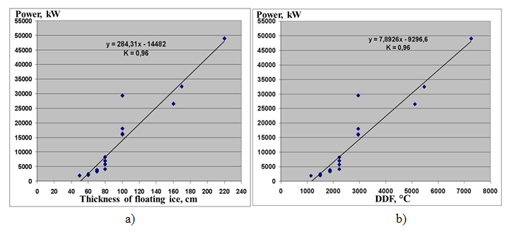
Figure 3 – Relationship between the designed power of icebreaker and the thickness of floating ice (a) or the sum of degree-days of frost (b) associated with lower limit of designed icebreaking capability.
a) ice thickness and average power of actual icebreakers operated in different seas;
b) ice thickness corresponding with lower limit of designed icebreaking capability, and designed power of icebreaker.
Figure 4b represents the combined plots of correlation between:
a) sum of degree-days of frost and average power of actual icebreakers operated in different seas;
b) sum of degree-days of frost, corresponding with lower limit of designed icebreaking capability, and designed power of icebreaker.
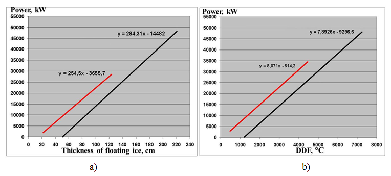
Figure 4 – Relationships between power of icebreaker and a) designed (black line) and average actual (red line) ice thickness; b) designed (black line) and average actual (red line) sum of degree-days of frost.
Analysis of relationships in
the Figure 4a reveals that average power of icebreakers, which provide the satisfying
assistance of vessels in the Russian seas, exceed the optimal (designed) power
for equal ice thicknesses. This is due to fact that actual icebreakers often
operate in areas of hummocked ice, which require more power input to break it. Besides, ice conditions can be more difficult than
moderate.
Figure 4b is of special interest. Analysis of relationships reveals that sum of degree-days of frost during winters with moderate ice conditions is significantly less (by about 1000oC) than sum of degree-days of frost corresponding with power of icebreakers usually operated in the Russian seas. Icebreaker fleet, thus, has considerable power reserve in case of more difficult than moderate ice conditions. To evaluate whether this reserve power is sufficient to operate in conditions of extremely severe winter, the deviations of extreme values of DDF from mean values are calculated (Table 13). According to the data, the reserve is sufficient.
Table 13 – Deviations of extreme values of sum of degree-days of frost (DDFmax) from mean values (DDFmean)
|
Sea, sea region |
Observation station |
DDFma x |
DDFmean |
Δ DDF |
|
White Sea |
Archangelsk |
2325 |
1480 |
845 |
|
Gulf of Finland |
St. Petersburg |
1800 |
770 |
1030 |
|
Sea of Azov |
Rostov-on-Don |
1277 |
400 |
877 |
|
Northern Caspian Sea |
Astrakhan |
1240 |
460 |
780 |
|
Sea of Okhotsk, northern part |
Magadan |
2955 |
2300 |
655 |
|
Sea of Okhotsk, Central-southern part |
Poronaysk |
2276 |
1720 |
556 |
|
Mean |
790 |
|||
Conclusions
1. Sum of degree-days of frost is sufficient to characterize ice conditions in the non-Arctic seas and can be used alone to determine the type of ice conditions. To chara
2. Sum of degree-days of frost can be also used for calculation of powers of icebreakers in particular ice conditions to set operating areas.
3. The power of the modern icebreaking fleet enables to navigate successfully in the Russian seas equally in conditions of mild and moderate winters, and in conditions of severe and extremely severe winters.
4. Icebreaker fleet has considerable power reserve which is sufficient to cover all possible deviations of temperature regime which can turn moderate ice conditions into difficult.
5. Long-term ice forecasts of the forthcoming ice navigation season predict mild and moderate winters corresponding with easy and moderate ice conditions due to global warming.
6. The power of icebreakers built in 21th century exceeds significantly the power of icebreaker fleet in the latter half of the 20th century. Meanwhile, two opposite processes are observed: increasing power of built and designed icebreakers from the one hand, and decreasing ice thickness in all Russian seas due to sustainable warming from the other. Thus, the approach of classification of ice conditions into easy, moderate and difficult, which is based on temperature variability (DDF), doesn’t represent real challenges of ice navigation.
7. Actually challenging conditions for ice navigation are revealed to occur in following situations:
- Lack of icebreakers for assistance due to increasing ship traffic on the route;
- The beam of an icebreaker is insufficient to assist super-ships (for ex., super tanker with beam of 50m);
- The main icebreaker in the region is underpowered for moderate ice conditions in the sea (for ex., IB “Magadan” in the Sea of Okhotsk);
- Icebreaking capability is decreased due to exhausted lifetime;
- Convoy of vessels meets with hummocked and ridged ice zone; there is presence of vessels with ice class which is not in compliance with moderate ice conditions in the sea;
- A technical accident.
8. The concept of easy, moderate and difficult ice conditions corresponding with winter severity is still used by navigators in excuse of problems during their winter navigation, though ice conditions are usually not the main challenge. Obviously, during the loss of way in ice as a result of any reason, the presence of ice complicates a situation and turns almost any ice conditions to difficult.
References:
2. Dumanskaya I. O. Method of long-term forecast of ice conditions in the Tatar Strait, the sea of Okhotsk and the Bering sea, based on the use of statistical modeling// Informational collection of the Hydrometeorological center of Russia. 2018. No. 45, p. 117-126.
3. Dumanskaya I. O., Kotilevskaya A. M., Fedorenko A.V. Ice conditions of the seas of the European part of Russia in the conditions of climatic changes (lessons of winter 2007-2008)// Meteorological. 2008. No. 2, p. 134–144.
4. Karelin, D. B. Influence of salinity of water and currents on the ice growth// Problems of the Arctic. 1943. No. 1, p. 144-149.
5. Mironov E. U. Some regularities of ice thickness distribution in the Arctic basin//Proceedings of the Russian Geographical Society.1986. Vol. 118. Issue 3, p. 202-207.
6. Mironov E. U., Kuznetsov I. M. Some features of spatial unevenness of the thickness of stationary and drifting ice. Sat. Research of ice conditions of the Arctic seas, methods of calculation and forecast// Proc. AARI. 1990. Vol. 423, p. 42-53.
7. Rules of classification and construction of ships. Volume 1. Saint-Petersburg: Publishing house of the Russian Maritime register of shipping, 2015. 580 p.
8. Rules of navigation in the waters of the Northern sea route. Moscow: Publishing house of the Ministry of transport of Russia, 2013. 18 p.
9. Accounting for ice conditions in hydrometeorological support of winter swimming in the Sea of Azov. Edited by P. A. Gordienko. Leningrad: Hydrometeoizdat, 1979. 106 p.
10. Accounting for ice conditions in hydrometeorological support of winter swimming in the Baltic Sea. Edited by P. A. Gordienko. Leningrad: Hydrometeoizdat, 1979. 167 p.
11. Accounting of ice phenomena in hydrometeorological support of winter swimming in the Caspian Sea. Edited by P. A. Gordienko. Leningrad: Hydrometeoizdat, 1983. 131 p.
12. Yulin A. V., Charitonov M. V., Pavlova E. A., Ivanov V. V. Seasonal and interannualchanges of ice massifs in East Siberian sea// Arctic and Antarctic Research. 2018. No. 3. p. 229-240.

")
")
")
")
