
Development of the Far North territories is such a process of human interference that causes certain changes in natural environment. Fields development and relative technological processes, being the main type of man-made burden, have negative influence on all components of the environment. The ecosystems of the Far North are characterized by their low ability of self-recovery, so the impact of extraction of mineral resources and its consequences in severe climate conditions increase manyfold. In order to solve the existing environmental problems and ensure sustainable development of the region, it is necessary to have objective information about the state of the environment. The only possible way to obtain such information is monitoring, which includes a system of observations, assessment and forecast of the state of the natural environment, the results of which will provide a comprehensive assessment of the ecological state of the environment, the degree of anthropogenic impact, as well as allow to make forecasts of environmental situations taking into account external and internal environmental factors.
Key words: the Far North,environmental monitoring, human impact, environmental control.
The territory of the Far North of Russia is about 11.4 million square kilometers, and this territory is inhabited by about 10 million people [1]. Despite the small population density, the natural environment of the Far North is subject to significant anthropogenic impact.
Human impact is primarily associated with the search for oil and gas fields and their further exploitation. Construction and operation of oil and gas facilities always affect flora and fauna of the territory. The main types of impact are: alienation of territory, flooding or drainage of land, pollution of environmental components, laying of roads and communication lines, deforestation and change of land use patterns, violation of tundra coat in the Far North, change of hydrological regime of water bodies, as well as noise, light, vibration and electromagnetic effects.
Thus, serious damage to the environment is caused in the process of construction and operation of oil fields. Drilling rigs, oil and gas collection stations, treatment stations, pipelines, slurry barns are potential sources of pollution. One of the dangerous types of technogenic impact on the landscape is drilling of oil and gas wells, accompanied by contamination of soils, surface and groundwaters with chemical reagents, oil, drilling fluids, physical disturbance of soil and vegetation cover and temperature regime of permafrost soils [2]. It shall be also kept in mind that pollutants penetrating in one of the natural environments (air, water, soil) are involved in the overall migration of substances and then spread in all environments [3].
Low air temperatures and high water content of the territory do not contribute to the intensification of chemical processes and lead to the accumulation of industrial waste. Deformations typical for the region of landscape elements result in stimulation of thermokarst, erosion, heaving processes, flooding and waterlogging [4].
Moreover, the geographical location, climatic and meteorological conditions, specific terrain relief, characterized by a high degree of waterlogging, also contribute to the occurrence of emergency situations in the mining fields.
Various physical and geographical processes, as well as human activity, significantly change the hydrological system of the Far North, affect both landscape in general and vegetation in particular. There are significant changes in permafrost landscapes. So, for example, sphagnum-lichen swamps pass into thicket swamps and push permafrost top layers deeper and build up topwaters horizon. The basins of the drained lakes are gradually occupied by sedge-sphagnum swamps. Various subtypes of sphagnum swamps appear on the site of newly formed thermoerosional hollows. Flooding within permafrost areas contributes to the formation of non-permeable taliks with a thickness of frozen rocks for several meters and the formation of biologically dead bodies of water. Floodings of pine forests cause the death of trees layer, grass and shrub layer, and also cause the formation of grassy swamps, usually of a small size. But the worst possible damage is caused to the most productive North Taiga floodplain forests, where all vegetative layers are completely destroyed and barely-passable horsetail swamps are formed [4].
Due to the increase in anthropogenic impact, it is necessary to monitor changes of the natural environment both during natural processes and during the construction, operation, repair and liquidation of various industrial facilities. Based on the above said, it can be concluded that there is a strong need for environmental monitoring, both background and operational.
Monitoring, in general, is a set of measures to determine the state of the environment and to observe changes occurring in it, including a system of observation, assessment and forecast. The block scheme of the monitoring system is shown in Figure 1.
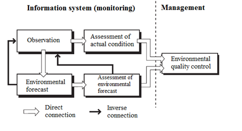
Figure 1. Monitoring system block scheme
It shall be taken into account that the monitoring system itself does not include any activities on environmental quality management, but, ideally, it becomes a source of information necessary for making some environmentally significant decisions.
Background environmental monitoring
It is extremely important to observe the state of the natural environment and the changes occurring in it during natural processes, especially in the Far North. This type of environmental monitoring is called background monitoring. The regularity of such studies allows to determine the long-term dynamics and assess the state of the environment. The objects of observation are the components of the natural environment. During the background monitoring constant hydrometeorological observations and determination of pollutants are carried out.
The indicators of hydrometeorological observations are: air temperature and humidity, wind speed and direction, atmospheric pressure, cloudiness, sunshine, atmospheric phenomena (fog, snowstorm, thunderstorm, etc.), the amount and intensity of precipitation, snow cover, soil temperature (at a depth of 20 cm), the state of the soil surface, temperature, humidity, wind speed, thermal balance. Following indicators are determined for the water bodies: level, flow rate, water temperature, waves, currents, ice cover, distribution of aquatic vegetation, groundwater level. The frequency of observations is standard as per the hydrometeorological service.
In addition to determining the hydrometeorological parameters, the atmospheric air is determined by the content of suspended solids, aerosol turbidity, concentrations of ozone, carbon oxides, sulfur and nitrogen, sulfates, petroleum hydrocarbons, 3,4-BP, DDT and other organochlorine pesticides, lead, cadmium, mercury, arsenic.
Atmospheric precipitations and snow are checked for lead, cadmium, mercury, arsenic, 3,4-BP, DDT and other organochlorine pesticides, pH, major cations and anions. Frequency of observations: wet precipitation integral sample for 10 days and 1 month; dry precipitation integral sample for 1 month; snow integral sample to the full depth prior to melting of snow cover.
Surface waters and groundwaters, suspensions, bottom sediments and soil are checked for lead, cadmium, mercury, arsenic, 3,4-BP, DDT and other organochlorine pesticides, pH and biogenic elements. Frequency of observations: water and suspensions are checked during their characteristic hydrological periods (high water, summer runoff low and winter runoff low, rainfall floods); bottom sediments and soil are checked once a year.
Biological objects are checked for lead, cadmium, mercury, arsenic, 3,4-BP, DDT and other organochlorine pesticides. The frequency of observations depends on the nature of the object.
One of the special cases of background monitoring is the background monitoring of areas for proposed construction of industrial and energy enterprises, geological exploration and subsequent mining. The purpose of such background monitoring is to determine the impact of a new anthropogenic source of pollutants on the region. Therefore, it shall be organized and started as early as possible, preferably at the beginning of the development of the technical project, and continue during the construction period. If the observation period before the launch of the object is long enough, the reliability of the forecast of the background state of the region and the assessment of the impact of a new source of pollution increases. The observation program in this case shall consider the pollutants that will be emitted by the new object, and the frequency of observations shall be increased as much as possible.
Operational environmental monitoring
In addition to background monitoring, it is also necessary to monitor changes in the state of the natural environment both during operation and during construction periods, as well as during repair and liquidation of various industrial facilities. This leads to the need for operational environmental monitoring.
The system of operational environmental monitoring is an obligatory component of the system of operational environmental control of an object or enterprise. Operational environmental control is carried out to ensure and comply with the current environmental legislation, rational environmental management, development and implementation of environmental action plans, environment enhancement[1].
It shall be borne in mind that observations under normal environmental conditions are recommended to be carried out at least twice during the period of work. Sampling shall be carried out selectively in accordance with the schedule binding to the warm season (June-September) – when sampling natural surface waters, sediments and soils; and in winter – when sampling snow. Checking background indicators shall be made before the start of work, re-examination – upon completion of construction or liquidation of objects [5].
Means of ecological control
Operational and background monitoring involves the use of the means of ecological control, which, from the point of view of the research methods, can be divided into remote and ground methods.
Remote methods are based on registration of own or reflected signal of wave nature and are carried out by means of sounding fields (electromagnetic, acoustic, gravitational) and transfer of the received information to the sensor. The remote sounding scheme is shown in Figure 2.
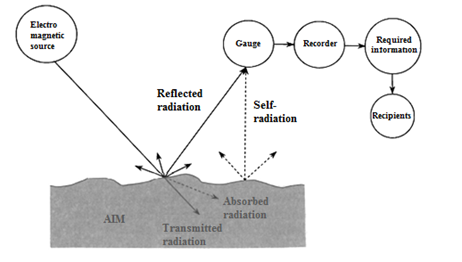
Figure 2. Remote sounding scheme
The obvious advantage of remote measurement, especially in the Far North, is the possibility of continuous and remote determination of average concentrations of harmful substances at some area (in contrast to ground methods, which give concentrations only at one point), as well as the assessment of the vertical distribution of impurities characterizing the potential of pollution. In addition, these methods allow to assess the movement of pollutants in the atmosphere without analyzing samples at different points and, thus, to determine the influence of the source of pollution located at a distance of several kilometers, and to predict possible emergencies.
Ground methods are based on physicochemical and biological research methods. Conditionally, biological methods can be divided into methods of water bioindication and biotesting. The system of assessing the degree of pollution of atmospheric air, water bodies and soil, based on the account of the state of the respective ecosystems, is called bioindication. Bioindication methods are based mainly on two principles: registration of detection of characteristic organisms (bioindicators) and analysis of species structure of biocenoses. In contrast to bioindication, biotesting methods are a characteristic of the degree of impact on aquatic biocenoses. These methods make it possible to obtain sufficiently reliable data on the toxicity of a particular sample of contaminated water, that is why such methods are considered to be almost chemical.
Physico-chemical methods are methods of analysis used in modern laboratories engaged in environmental control, including many variants of optical methods of analysis (for example, spectrophotometry in visible spectrum, UV- and IR- spectra), separation methods based on gas, liquid and thin-layer chromatography, radiometric methods (used in a limited way, as they require specially prepared laboratories) and electrochemical methods, such as voltammetry and ionometry, which have certain advantages as per low cost and the necessary expenses on operation. Physico-chemical methods, giving the opportunity to accurately determine the concentration of pollutants, however, do not allow to assess the real biological effects of individual substances and their complexes and, moreover, of the products of their transformation.
When determining hydrometeorological indicators, as a rule, the following equipment is used: actinometers, anemometers, barometers, hygrometers, thermometers and other devices. Meteorograph is used for complex measurements of atmosphere meteorological characteristics, it includes devices that record changes in humidity, temperature and pressure. Also, the study of the state of natural processes involves the use of non-contact methods of control (acoustic, radio-acoustic, radar), allowing to obtain spatial and temporal information about changes in environmental parameters.
Control of air pollution is carried out by various remote methods of research. Recently, lidar (laser) methods have been actively developed for monitoring the atmosphere. However, if it is impossible to use expensive equipment for remote assessment of the state of the air environment, ground methods are used, implying initial sampling on the ground and their further analysis in a specialized laboratory. The study of selected samples of atmospheric air is often carried out by spectroscopy and chromatographic methods of analysis [6].
The monitoring system for the state and quality of the water environment includes monitoring of the water level using water meters, as well as various recorders. The measurement of water surface temperature is usually carried out with the help of thermometers, but it is also possible to use active radar methods. Radio brightness method is used for water temperature measurement. For continuous remote control of the depth of the reservoir, profilographs are used, which are divided into mechanical, hydrostatic and acoustic ones according to the principle of operation. The float method is used to measure the flow rate of rivers, with the use of surface, depth and integration floats, as well as hydrometric current meters. Monitoring of water pollution by remote non-contact methods is carried out using aerial photography. The most promising remote non-contact methods of oil control are laser fluorescent, radiometric and some others. When using ground methods to control water pollution, it is necessary at first to take samples and then determine the content of substances in the laboratory.
Radar aerial photography is used to monitor the biolithosphere. Radar aerial photography is used for large areas, it helps to get the image of small scales, so it is a great summering way to study the landscape features, which is especially important for the territories of the Far North.
One of the practically useful methods of soil control is the method of studying surface radio waves in its various variants. But, nevertheless, in practice, the use of ground-based methods of soil research is more common.
Remote monitoring of seasonal snow cover plays an important role in environmental research. The study of snow cover (the boundary of the cover, depth, density, temperature, moisture content) is carried out, as a rule, with the help of active and passive radio brightness methods.
The following methods of remote indication are used to study the geological structure of the earth's crust, development and exploration of mineral deposits: photography, magnetic methods, gamma-ray photography, electrical exploration, gravitational exploration, radiolocation. Currently, environmental interest in these methods is especially evident in the design of fuel and energy complexes, the survey of railway tracks, the choice of the location of dams, power plants, the design of pipelines, canals, tunnels and other facilities.
Thus, when monitoring the environment, it is possible to use a variety of means and methods of control. The choice of means of environmental control depends, first of all, on the tasks set, and the information received must be reliable, complete and up-to-date.
Development of the Far North territories is such a process of human interference that causes certain changes in natural environment. Fields development and relative technological processes, being the main type of man-made burden, have negative influence on all components of the environment. The ecosystems of the Far North are characterized by their low ability of self-recovery, so the impact of extraction of mineral resources and its consequences in severe climate conditions increase manyfold. In order to solve the existing environmental problems and ensure sustainable development of the region, it is necessary to have objective information about the state of the environment. The only possible way to obtain such information is monitoring, which includes a system of observations, assessment and forecast of the state of the natural environment.
Continuous background monitoring shall be carried out in order to monitor changes occurring in natural processes, while increased attention shall be paid to industrialized areas, their environmental safety during the design, construction, operation and liquidation of various industrial facilities. To carry out a full-fledged analysis of the state of the natural environment, observations shall be comprehensive, cover all components of the environment, be periodic, and the obtained data shall be representative.
In order to improve the quality of environmental information, it is necessary to develop and revise scientific-methodological basis for determining levels of contaminants, carry out comprehensive research assessments of the environment of the Far North, it is also necessary to improve technical support of the monitoring network, and also to expand the list of observable parameters. There is a high need to pay attention to the optimization of the process of information support based on geoinformation technologies, to create environmental databases, to make them publicly available. It is also necessary to ensure functioning and further development of the monitoring system in order to develop mechanisms for environmental quality management and rational environmental management. It shall develop on the basis of existing and prospective services, observation systems and modern information technologies. For this purpose, it is also necessary to develop new methods and elaborate uniform methodical and metrological bases.
The results of the surveys carried out within the framework of monitoring will provide a comprehensive assessment of the ecological state of the environment, the degree of anthropogenic impact, as well as allow to make forecasts of the development of environmental situations taking into account external and internal environmental factors.
References:
2. Anderson R.K., Mukatanov A.Kh., Boyko T.F. Ekologicheskie posledstviya zagryazneniya pochv neft'yu [Environmental effects of oil pollution of soils]. Ekologiya [Ecology], 1980, no. 6, pp. 21-25. (In Russian).
3. Saksonov M.N., Abalakov A.D., Dan'ko L.V. et al. Ekologicheskiy monitoring neftegazovoy otrasli. Fiziko-Khimicheskie i biologicheskie metody: ucheb. Posobie [Environmental monitoring of the oil and gas industry. Physico-Chemical and biological methods: textbook. allowance.]. Irkutsk: Irkutsk University, 2005, 114 p. (In Russian).
4. Bykovskiy V.A. Okhrana prirody pri razrabotke neftyanykh mestorozhdeniy Kraynego Severa [Environmental protection in the development of oil fields in the Far North. Dis. сand. tech. of sciences]. Yekaterinburg, 2000, 161 p. (In Russian).
5. Kustysheva I.N. Razrabotka metodiki okhrany zemel' pod ob"ektami neftegazovogo kompleksa s uchetom regional'nykh osobennostey Kraynego Severa. Dis. kand. tekhn. nauk [Development of land conservation methods under oil and gas facilities taking into account regional features of the Far North. Dis. cand. tech. of sciences]. Novosibirsk, 2016, 131 p. (In Russian).
6. Volkodaeva M.V., Volodina Ya.A. O metodakh opredeleniya kontsentratsii formal'degida v atmosfernom vozdukhe [On methods for determining the concentration of formaldehyde in atmospheric air]. Ekologicheskie sistemy i pribory [Ecological systems and devices]. 2017, no. 2. pp. 3-9. (In Russian).
[1] Ministerial directive document 39-1.13-081-2003. System of operational environmental monitoring at gas industry facilities. The rules of design.


")


")

")