The Arctic Zone of the Russian Federation (AZRF), being a territory of prospective development and reclamation, requires increased attention to the problems of maintaining the sanitary and epidemiological well-being of the population considering specific climatic and socioeconomic factors. These circumstances force the development and implementation of non-standard managerial decisions in the selection of technological development of territories, the characteristics of the work and life of people in these conditions.
To solve problems in the area of environmental protection and sanitary and epidemiological well-being of the population, various electronic informational and analytical public resources based on geographic information system (GIS) technologies have been developed and are actively used. The advantage of GIS technologies is the convenience of collecting, analyzing and visualizing information directly related to the territory, which is especially important when working with large arrays of information linked to large territories.
That said, when it comes to the AZRF, such resources are either absent or do not address the sanitary and epidemiological well-being of the population.
The authors have developed the concept of a geoportal of the sanitary and epidemiological status of the AZRF based on GIS which could be an extensive electronic database of environmental factors and the population health status and also serve as an effective tool for assessing the sanitary and epidemiological well-being of the population with a spatial analysis function.
A test version to be posted on the Internet has been developed and work on populating it with the up-to-date information on environmental and public health factors is in progress.
Keywords: sanitary and epidemiological well-being, health risks, drinking water, outdoor air, Russian Arctic.
Introduction. The Arctic Zone of the Russian Federation (AZRF) is currently becoming a zone of intensive development involving hundreds of thousands of people into production activities in this region. Implementation of the assigned tasks, including those on the development of industrial, engineering and transport infrastructure, on the creation of jobs, the arrangement of settlements, is inextricably linked with the provision of safe working and living conditions in the territories with significant climatic characteristics affecting first of all the sanitary, hygienic and epidemiological situation, preservation of people’s health and life [1]. This circumstance necessitates consideration, discussion and resolution of issues related to ensuring sanitary and epidemiological well-being in the developed territories of the Arctic as a prerequisite for the effective implementation of investment projects planned by the government. This, in turn, makes it necessary to justify, develop and implement non-standard managerial decisions not only in the choice of technological development of territories, but primarily in relation to the work and life of people in these conditions [2].
Among the high-priority national and investment projects in the development of the Arctic which require a comprehensive sanitary and epidemiological expertise, the following should be listed:
- Creation of 8 pivot zones for the development of the Arctic [3, 4];
- Establishment of a single operator of the Northern Sea Route [5];
- Digitalization of the Arctic: telemedicine, telecom and communication;
- Construction of the railway "Northern Latitudinal Railway";
- Implementation of the federal target project “Pure Water”: providing the population with pathogen-free drinking water; creation of an Interactive Map for Drinking Water Quality Control in the Russian Federation;
- Implementation of the federal target project “Clean Air”: reduction of atmospheric air pollution in large industrial centers; reduction of pollutant emissions into the air; creation of an effective system for monitoring and control of air quality;
- Solving the problems of municipal waste and production waste and their disposal.
To solve the above listed problems, it is necessary to create a system for the effective assessment and management of the sanitary and epidemiological situation in the Arctic considering special attention to maintaining public health, reducing mortality and increasing life expectancy of the population, as well as developing measures to prevent morbidity. An important factor determining the effectiveness of these measures is the completeness, reliability and quality of the source information that directly affects the nature of decisions to be made [6].
Presently a fair amount of electronic information and analytical public resources based on geographic information system (GIS) technologies have been developed for solution of various problems in the field of environmental protection and sanitary and epidemiological well-being of the population, and they are actively used both in Russia and in other countries [7, 8, 9].
The main advantage of GIS technologies in these areas is the convenience of collecting, analyzing and visualizing of various information directly related to the territory (“map-linked”) [10, 11].
The Government of the Russian Federation has adopted the Concept of creation and development of spatial data infrastructure (SDI) of the Russian Federation. Regional and departmental SDIs are also being formed, providing for the creation of specialized, industry-specific and thematic geoportals. Various regional electronic resources based on GIS technologies (regional geoportals of the constituent entities of Russia) have been created and are actively used, however, none of them covers the problems and tasks of ensuring sanitary and epidemiological well-being, especially in the Arctic Zone [11].
Targets and goals. In consideration of the foregoing, for the purpose of collecting and analyzing information on the sanitary and epidemiological well-being status, there was set a task to create and develop a geoinformation portal (Geoportal) “Sanitary and epidemiological well-being of the population in the Arctic Zone of the Russian Federation”.
The Geoportal concept is based on a geographic information system (GIS), a database server and an array of information about environmental factors, public health, socio-economic and medical-demographic indicators using information and analytical tools and spatial data processing methods [12].
The Geoportal is created as a multi-level system for collecting, storing and analyzing data which is implemented on a cartographic basis and includes:
- the actual cartographic part (the “atlas” in the traditional sense);
- various features associated with the map;
- a set of analytical and calculation methods;
- managerial and expert decisions based on data analysis.
The concept of the Geoportal is schematically shown in Figure 1.
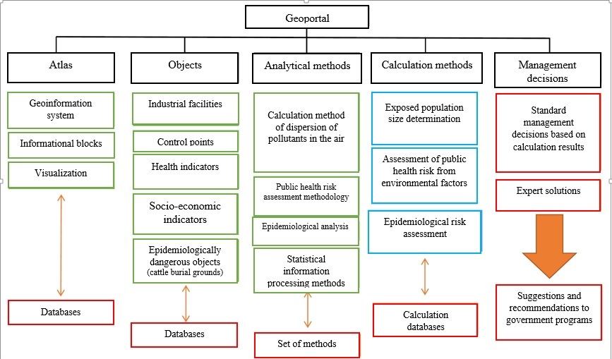
Fig. 1. Concept of the Geoportal
ArcGis GIS in the server version of ArcGis Server v.10.7 Advanced Enterprise is used as a software environment for implementing the technical capabilities of the Geoportal and for visualizing information on a cartographic basis. For storage and loading of databases (DB) in the GIS, the SQL series of the database management system (DBMS) is used.
The visual representation of the Geoportal is implemented as a website accessible on the Internet with access through a web browser window with customizable multilevel access rights.
The following layers (presentation levels) of data are implemented in the Geoportal:
- AZRF as a whole;
- Territorial subjects of the AZRF;
- Areas of the subjects;
- Settlements;
- Separate objects: infrastructural, point and areal (polygonal) objects.
Currently, the Geoportal is in the mode of technical debugging and populating it with data. Given the software, hardware and technical capabilities, it is planned to populate the Geoportal with the following volume and list of data:
• Demographic indicators – 19 indicators;
• Health status of the population – over 2100 indicators;
• The state of the population living environment – over 1200 indicators;
• Socio-economic indicators of the territories – more than 20 indicators;
• Food quality – over 60 indicators;
• Natural climatic data and territorial geographical indicators;
• Infrastructure and economic indicators of the development of the territories.
An example of the database structure is shown in Figure 2.
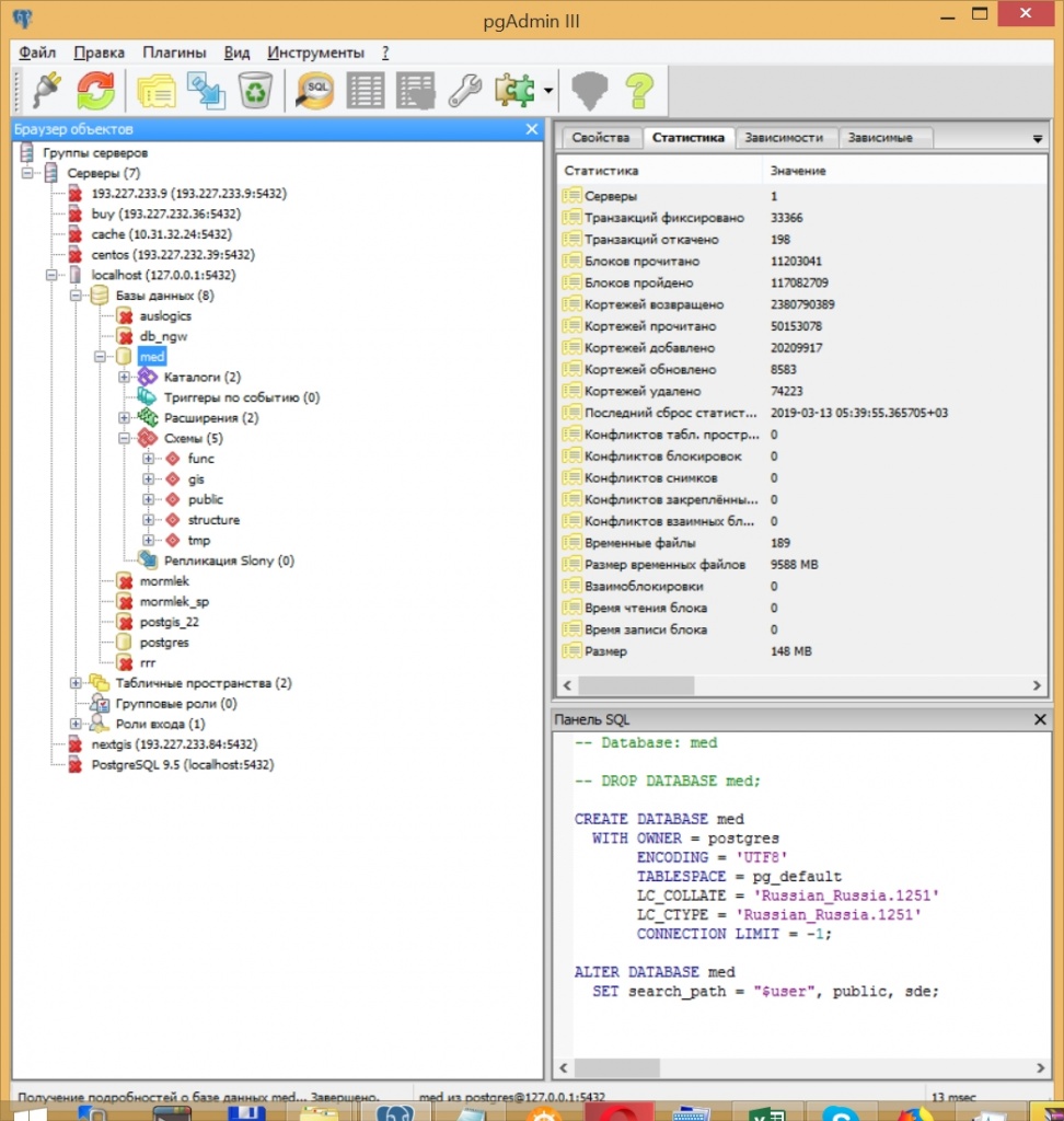
Fig. 2. Example of Geoportal database structure
To perform analytical tasks, the Geoportal is equipped with a wide range of functionality and various tools, in particular:
• Statistical analysis of sample arrays of spatially related data;
• Spatial analysis of the distribution and correlation of indicators, its visualization;
• Retrospective correlation analysis to identify causal relationships.
The following sources of information are used as the main data sources for populating the Geoportal with information:
- Forms of federal and sectoral statistical monitoring of the state of public health and the environment;
- Templates of the Federal Information Fund SGM (FIF SGM);
- Data from Earth’s remote (satellite) sensing (ERS);
- Reports of the Federal State Statistics Service (Rosstat);
- Information and analytical system of Rospotrebnadzor.
In view of the actual and predicted sanitary and epidemiological situation, the capabilities of the Geoportal will allow the following:
1. Development of general schemes for the development of the AZRF territories;
2. Planning of investment projects;
3. Development of measures to prevent and reduce the morbidity of the population, including occupational morbidity;
4. Development of targeted social programs for various groups of the population considering various specifics;
5. Creation of programs for comprehensive improvement of territories and ensuring hygienic and environmental safety of the population
6. Improving the SGM system;
7. The ability to quickly access the list of medical-demographic and socio-economic information online via the Internet portal for a wide range of authorized organizations (authorities, medical institutions, Rospotrebnadzor, etc.).
With the help of spatial analysis tools, it is possible to graphically visualize and rank territories of various levels (subject, district, settlement) by number, population density, intensity of morbidity indicators (both general and by individual nosologies) or the severity of indicators of environmental factors.
The statistical analysis tools allow to select certain areas of interest and compare the indicator of interest in the dynamics for a specific period.
Similarly, it is possible to visualize the location of monitoring points for the quality of drinking water and atmospheric air, estimate their amount and territorial distribution in different regions (subjects, settlements) and make a correlation between density and population and the number of monitoring posts.
The results of long-term monitoring that are linked to a specific territory can be compared in dynamics by a combination of factors or by a separate indicator which makes it possible to quickly visualize successful or unsuccessful territories by applying spatial analysis tools.
Examples of visualization of spatial data on the sanitary-epidemiological situation in the Geoportal are presented in Figure 3 and Figure 4.
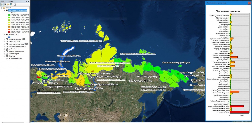
Fig. 3. Example of ranking the AZRF territories by demographic indicators.
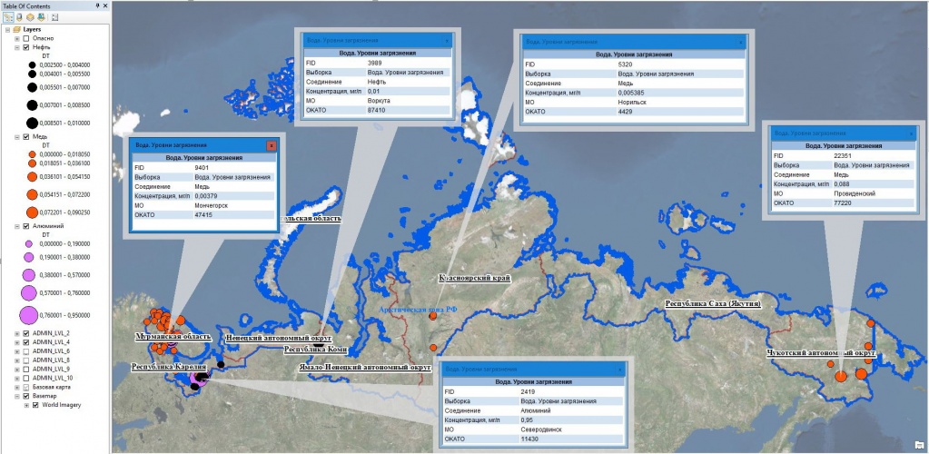
Fig. 4. Example of visualization of water pollution levels of centralized drinking water supply in the AZRF
In the process of the Geoportal development, the capacity of work with local data, with their subsequent refinement, for example, to the level of a separate industrial enterprise (or even a separate source) was implemented. In this case, in the process of sanitary-epidemiological assessment or examination, specialists can use verified and up-to-date information about the parameters of the enterprise’s impact on the population’s environment, the levels of the population exposure for a given period of time including the assessment of the risk to the residents’ health.
The organization of data on the Geoportal is indicative of the spatial relationship of the industrial site and the habitable area, the potential impact zone of the enterprise, the sources of pollutant emissions and other components of the assessment of the sanitary and epidemiological situation in a convenient visual and digital form.
Calculations in the system can be performed for any point of the estimated space which allows operating with verified quantitative indicators of the exposure load.
Given the described capabilities of the Geoportal, the following points appear to be promising and feasible:
- Implementation of the Geoportal as an analytical tool into the practice of the authorities and institutions of the Rospotrebnadzor, as well as the executive bodies of the AZRF constituent entities.
- Ensuring automatic updating and uploading of relevant data on environmental factors and the population health status from various existing information and analytical systems – both Rospotrebnadzor and within interdepartmental interaction and integration (Roshydromet, Rosprirodnadzor, Ministry of Health, etc.);
- Use of the Geoportal results in the development and implementation of state, investment and regional projects and development programs of the AZRF.
Conclusion. Given the significant amount of data planned for placement, storage and visualization, these activities are planned as long-term work aimed at the systematic collection of new information, analysis of existing data and expanding the list of indicators, which, according to the authors, should allow to identify causal relationships and correlations between various factors (groups of factors) and the public health status.
Thus, the created Geoportal should become, on the one hand, an information-analytical system with an extensive database of environmental factors and the public health status, and, on the other hand, an effective tool for assessing the sanitary and epidemiological well-being of the population of the Russian Arctic in general and in individual territories with a wide list of spatial analysis functions which together will serve as a tool for substantiating the managerial decisions.
References:
2. S.A. Gorbanev. Main directions and tasks of scientific research of the North-West Scientific Center of Hygiene and Public Health of the North-West Scientific Center for Sanitary and Epidemiological Wellbeing in the Arctic Zone of the Russian Federation. // «Problems of Preservation of Health and Ensuring the Sanitary and Epidemiological Well-Being of the Population in the Arctic». Materials of the scientific-practical conference with international participation. 2017 - Publisher: OOO «IPK» Kosta». Pp. 8-13.
3. Voronina E.P. The formation of supporting zones for the development of the Arctic zone of the Russian Federation and ensuring their functioning: the use of Gap-analysis // Regional Studies. 2017.V. 4. No. 6. P. 60-69. DOI: 10.14530 / reg.2017.6
4. Andreeva E.N. Support zones in the Arctic: new trends in solving old problems // IVF. 2017. No. 9. C. 26-41.
5. Federal Law «On the State Atomic Energy Corporation» Rosatom» dated 01.12.2007 N 317-ФЗ (latest revision).
6. Yu.A. Novikova Interregional social hygienic monitoring – topical trend to provide sanitary-epidemiological wellbeing // Russian hygiene - developing traditions, rushing into the future. Materials of the XII All-Russian Congress of Hygienists and Sanitary Physicians. 2017. Moscow. - P. 140-143.
7. S.M. Tokarchuk, O. V. Tokarchuk, E.V. Trofimchuk Methodological basis for the creation of regional electronic ecologo-geographical atlases. Pskov Regional Journal. 2015 No. 22 // URL: https://cyberleninka.ru/article/n/metodicheskieosnovy-sozdaniya-regionalnyh-elektronnyh-ekologogeogr...
8. D.V. Yakovlev Geoportal of the Voronezh region - a tool for increasing the efficiency of circulation of regional spatial data // Vestnik Voronezh State University. 2012 T. 8 No. 1. P. 41-45.
9. A.P. Dexter, D.R. Strukov. Geoportal «Geoinformation system of St. Petersburg healthcare» in the Internet as an example of a system for managing the health territory. // Doctor and information technology. 2012 № 3 S. 58-63.
10. N.A. Chepikov Perfection of the system of socio-hygienic monitoring of the region using geoinformation technologies. // URL: https://cyberleninka.ru/article/n/sovershenstvovaniesistemy-sotsialno-gigienicheskogo-monitoringa-re.... (26.08.2018).
11. Fedorov V.N., Novikova Yu.A., Kovshov A.A. Actual issues of the practical application of GIS technologies in the activities of bodies and institutions of the Federal Service for Supervision of Consumer Rights Protection and Human Welfare // Collection of scientific papers of the All-Russian Scientific and Practical Conference with international participation «Preventive Medicine-2017» . T. 3.P. 225-230.
12. Gorbanev S.A., Kulichenko A.N., Fedorov V.N., Dubyansky V.M., Novikova Yu.A., Kovshov A.A., Tikhonova N.A., Shayahmetov O.H. Organization of an interregional monitoring system using gis technologies by the example of Russian Federation Arctic Zone. Hygiene and sanitation. 2018. Vol. 97. No. 12. S.1133-1140.

