
The paper presents preliminary results of data processing of special ship observations of ice cover in the Arctic Basin between Franz Josef Land and the North Pole in summer 2018. Distribution of total ice concentration and ice age on the route of navigation of the nuclear icebreaker «50 let Pobedy» is shown. Comparatively to 2006-2011, amount of old ice in this area increased, however average ice thickness dramatically decreased. Mean thickness of level old ice in 2018 was 160 cm, which is 65 less than in 2006-2011 years of observations, and 90 cm less than in 1991-1996. Mean thickness of first-year ice in 2018 was 90 cm, which is 35 cm less than observed in 2006-2011 and 60 cm less than in 1991-1996.
Keywords: Arctic Basin, ice thickness, ice concentration, ice age, ship observations
A first tourist voyage to the North Pole was made in 1990 aboard the nuclear icebreaker Rossia. Later such voyages become regular and were organized aboard icebreakers Sovetskiy Soyus, Yamaland, from 2008, 50 Let Pobedy. Every year from 1997 a nuclear icebreakers departs from Murmansk, passes through the straits of Franz Josef Land archipelago and continues to the North Pole through the ice cover of the Arctic Basin. Usually five North Pole voyages are organized every summer, but in 2017, there were six.
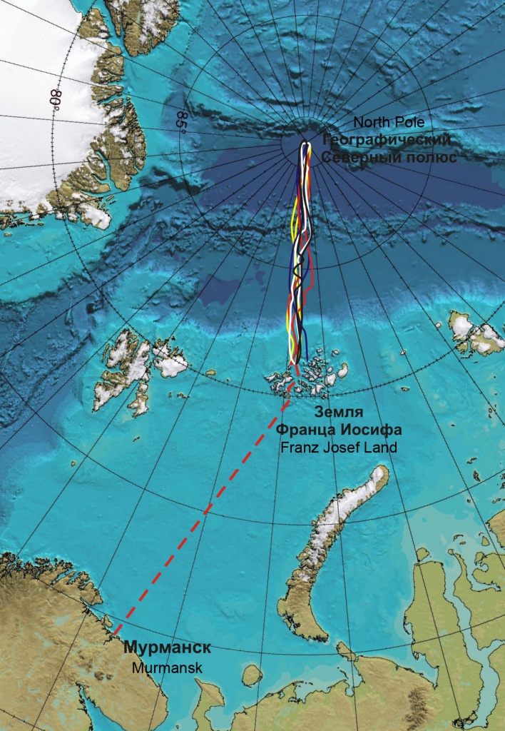
Figure 1 – Routes of 5 North Pole voyages aboard nuclear icebreaker 50 Let Pobedy in 2018 (June-August)
In 1991-1996 and 2006-2018 sea ice specialists of the Arctic and Antarctic Research Institute (St. Petersburg, Russia) participated in these voyages, obtaining unique data on sea ice cover to estimate its distribution and interannual variability between Franz Josef Land and the North Pole (Fig. 1). Routes of navigation in that area crossed the Transarctic Drift – one of the major elements of ice circulation in the Arctic Basin.
Despite on intensive development of remote sensing methods, satellite data do not give full and accurate information about all sea ice parameters in the Arctic. Sea ice cover on satellite images in the visible range is predominantly obscured by cloud. Radar images are not regular for the circumpolar area and difficult for ice detecting, particularly in summer as the ice melts. Data of passive microwave imagery are regular, but has a relatively low resolution and more appropriate for estimation of total area of ice cover.Ice observations are conducted in accordance to the AARI method [1] continuously along the entire route of navigation. Visual observations include observation of the complex of the main characteristics of the ice cover: development stage, total and partial ice concentration of each of the ice types observed, as well as their forms (horizontal size of ice floes), sea ice thickness and snow depth, hummock and ridge concentration, average and maximum ridge height, melt stage, ice compacting, orientation and size of fractures or leads. During the observations, homogeneous ice zones are delineated. It means the following: when the icebreaker first comes to the ice, coordinates and time of ice edge are fixed, than all sea ice parameters are determined around a ship at the first contact with the ice. Subsequently, when any parameter changes, an observer fixes coordinate and time - opens new ice zone, where all sea ice parameters are determined again. The same procedure continues during the whole expedition.
Simultaneously with visual observations, sea ice thickness is measured automatically by a digital TV-complex (STK). The STK records ice floes that are overturning near the hull during the icebreaker’s motion through the ice. Further sea ice thickness and snow depth is calculated with special software. The STK is a standard system of video controlling which was adapted by AARI research for special conditions of ship ice observations and severe weather [2].
The present research is based on preliminary results of visual ice observations made during the period from 14 June to 12 August 2018. Ice circulation in the Arctic Basin under the influence of atmosphere processes is the main cause in ice variability in the area of research. Sea ice formed in the shelf Arctic Seas becomes involved in the Transarctic Brift, and part of it to Beaufort Gyre with the center located at 78ºN, 150 ºE. Ice formed in the Laptev Sea is transported to the Greenland Sea in 2-3 years, in the East-Siberian Sea – in 3-4 years, and in the Chukchi Sea – in 4-5 years [3].
Thus, ice age on the navigation route of an icebreaker from Franz Josef Land to the North Pole depends on sea ice conditions formed in these seas during previous years. Figure 2 presents overview ice charts of ice conditions in the area navigated by the nuclear icebreaker 50 let Pobedyin summer 2018. When ice starts to melt, an interpretation of ice age on satellite images might be incorrect because of surface melt ponds. Therefore, officially in the AARI only ice concentration is shown on sea ice charts in summer period from 1 June until 1 October. An overview ice chart dated by 27-29 May 2018 is presented on Figure 2 (left) to estimate ice age distribution along the navigation route before cruises began in the summer. According to the overview ice charts, to the north of Franz Josef Land up to 83-84ºN thick ice (more than 120 cm) prevailed, and further to the North Pole old ice prevailed in the end of May.
Overview charts of ice concentration dated by 17-19 June and 5-7 August, which corresponded to periods of the first and fifth cruises, are presented on Figure 2 (center and right). Area of sea ice around Franz Josef Land significantly decreased during the summer as a result of melting processes and drift. The edge of the ice massif in the Arctic Basin moved to the north up to 83ºN. In the middle of June compact ice (ice with concentration of 10 tenths) prevailed in the circumpolar area, then in July leads and cracks formed there, as a result average ice concentration decreased to 9-10 tenths.
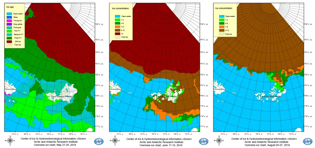
Figure 2 – Overview sea ice charts for the periods of 27-29 May (left), 17-19 June (center), 5-7 August (right) (more detailed information about sea ice charts at http://www.aari.ru)
Observed distribution of ice concentration and ice age are shown at Figure 3. Variability of percentage of first-year and old ice on the routes between Franz Josef Land and the North Pole is influenced by melting processes and drift. At the same time, more level and thin first-year ice melts earlier; therefore the percentage of first-year ice is decreasing faster in relation to old ice towards the end of summer (Fig. 3).
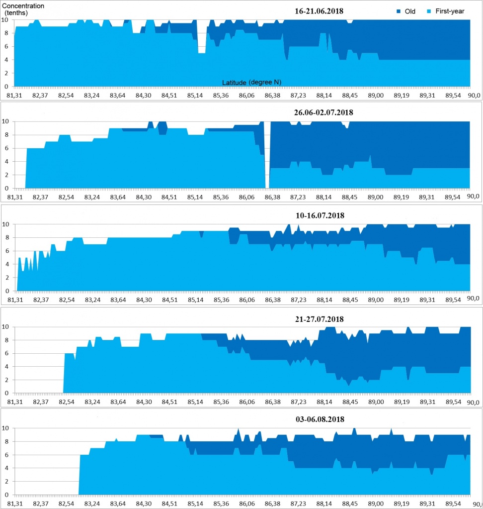
Figure 3 – Distribution of total ice concentration and ice age along the navigation routes of the nuclear icebreaker 50 let Pobedybetween Franz Josef Land and the North Pole during the five cruises in 2018 (within longitudes 45º and 55º E)
Ice cover north of the Franz Josef Land in 2018 was characterized by high ice concentration, low amount of leads and cracks and a large amount of old ice relatively to the period of 2006-2011 (Table 1). Nevertheless, average thickness of level ice in 1991-1996 was about 250 cm, in 2006-2011 – 225 cm and in 2018 it significantly decreased to 160 cm. Average thickness of first-year ice in 1991-1996 was 150 cm, it decreased to 125 cm in 2006-2011 and reached 90 cm in 2018.
Table 1 – Percentage between first-year and old ice along the routes of navigation in July
|
Year |
1991-1996 |
2006 |
2007 |
2008 |
2009 |
2010 |
2011 |
2018 |
|
First-year ice |
62% |
87% |
96% |
95% |
93% |
90% |
93% |
80% |
|
Old ice |
38% |
13% |
4% |
5% |
7% |
10% |
7% |
20% |
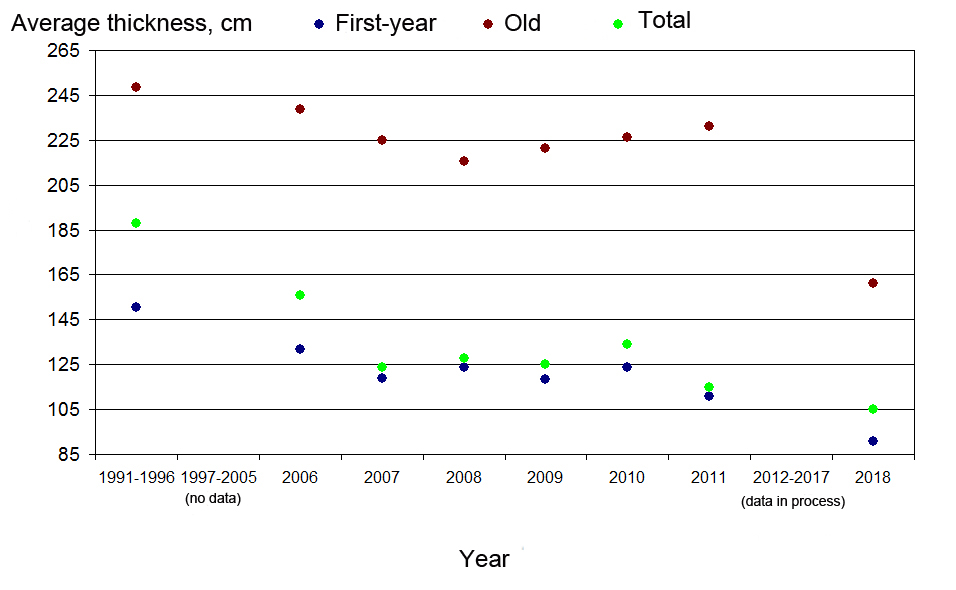
Figure 4 – Average thickness of level ice based on visual observations from icebreakers from the Franz Josef Land to the North Pole in July 1991-1996, 2006-2011 and 2018
Distribution and interannual variability of ice age, ice concentration and ice thickness is result of the complex of closely interconnected thermodynamic and hydrodynamic processes in the Arctic. During the period of ship-based observations of ice cover, from 1991 in the area between Franz Josef Land and North Pole, the average thickness of level ice decreased by 85 cm. Thickness of old ice decreased by 90 cm and first-year – by 60 cm. The main reasons for such ice degradation are increase of surface air temperature, changes in structure of atmosphere circulation, changes of radiation balance caused by changes in surface albedo, occurring during the previous decades [4; 5; 6; 7; 8]. Results obtained in present research for the periods of 1991-1996 and 2006-2011 correlate with general tendencies of changes in ice age and thickness, as measured from submarines and satellite data [9, 8 and references in this article]
To estimate the influence of each natural factor on changes of ice and thickness of ice in the area of research, detailed analysis of ice conditions for some previous years in shelf seas and in the Arctic Basin is necessary: speed and directions of ocean currents, atmosphere circulation, air temperature etc. Authors of the present research have been processing and analyzing all data, obtained during North Pole voyages from 1991 (as well as including other high-latitudinal expeditions). Measurements of sea ice thickness by STK are also in process, these data will allow further analysis of changes of ice cover in the Arctic Basin in greater detail.
The research was founded by RFBR No 18-05-60048.
Acknowledgements: Authors are extremely grateful to Bob Headland for his help to improve the grammar and readability.
References:
2. Frolov S.V., Tretyakov V.Yu., Kleyn A.E., Alekseeva T.A., Pryakhin S.S. Results of observations of ice thickness from the data of high latitudinal Arctic marine expeditions. Impact of Russia to the International Polar Year 2007/2008. Oceanography and sea ice. Moscow-Saint-Petersburg. 2011. Pp 374-385.
3. Observations of ice conditions: manual. Saint-Petersburg: AARI, 2009. – 360 p. (In Russian).
4. Alekseev G.V. Arctic dimension of global warming. Led I sneg Journal. 2014 №2 V. 54 P. 53-68.
5. Wang, J., Zhang, J., Watanabe, E., Ikeda, M., Mizobata, K., Walsh, J., Bai, X., and Wu, B.: Is the Dipole Anomaly a major driver to record lows in Arctic summer sea ice extent?, Geophys. Res. Lett., 36, L05706, doi:10.1029/2008GL036706, 2009.
6. Petoukhov V., Semenov V.A. A link between reduced Barents Kara sea ice and cold winter extremes over northern continents // Journ. of Geophys. Research. 2010. 115, D21111. doi.10.1029/2009JD013568
7. Liu Y., Key J.R., Wang X. The Influence of Changes in Cloud Cover on Recent Surface Temperature Trends in the Arctic // Journ. of Climate. 2008. V. 21. P. 705–715.
8. Ivanov V.V., Alexeev V.A., Alekseeva T.A., Koldunov N.V., Repina I.A., Smirnov A.V. Does Arctic ocean ice cover become seasonal? // Issledovanie Zemli iz Cosmosa. 2013. V 4. p. 50–65.
9. Kwok R., Untersteiner N. The thinning of Arctic sea ice // Phys. Today. 2011. V. 41. P. 36–41.


 of factors forming interannual variability of the Barents Sea and its individual areas ice coveren")


")


")
")
")
