The paper describes the principles of sonar surveying of ice-bottom topography directly from the Arctic sea-ice surface as an integrated method of morphometric research. Results of using sonar detection in the Laptev Sea are presented.
Keywords: morphometric parameters of ice, sonar studies, underwater photography, sonar, ice ridges, icebergs.
Introduction
The declared priorities of development of commercial production in the Arctic seas [1] require understanding of particular issues associated with formation and development of sea ice cover and its impact on industrial objects. One kind of integrated activities is morphometric research of ice ridges in landfast ice or drift ice in the Arctic seas. Nowadays accurate and prompt plotting of the surface of ice ridges and icebergs is based on aerial photography using a manned or unmanned aerial vehicle, and tacheometric surveying. Morphometric measurements [2], thermal drilling [3] and sonar surveying [4] from the ice surface allow creating rough model of both inner structure and bottom surface of ice ridges. Accuracy of these methods for ice-bottom detection is up to 1m and is not enough to specify unambiguously conditions of formation of an ice ridge.
To identify ice-bottom surface of an ice ridge with similar accuracy as for above-water ice surface, the integral surveying by sonar and television units is needed [5]. In this paper we discuss the particularities of the integrated approach by the example of the use of Sonar 881 as a part of a special sonar system in AARI.
Materials and methods
Technical equipment
Sonar system consists of profiling scanning sonar Imagenex 881A with rotatory actuator drive Azimuth Drive and orientation module. Unlike multibeam sonar systems, the use of single-beam transducer (Figure 1) allows immediate processing and digitizing of signal.
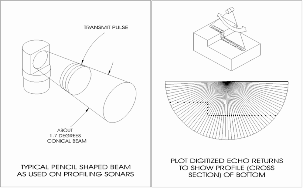
Figure 1. Operational scheme of a single-beam sonar.
The sonar system has rather small size (Figure 2), it is capable to make measurements from the depth of up to 100 m, and the scale range is up to 200 m with accuracy of 1 cm. The device requires holes of 0.25 m² drilled in sea ice for lowering. Rugged laptop computer Panasonic is used for surface control, the connection is via COM port 485 RS to allow high-speed data transmission. Power is applied via 24 VDC power supply or generator with power converter to 24 VDC output.
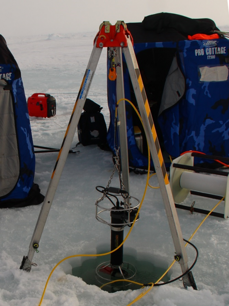
Figure 2. The sonar system before diving
Operating procedure
At the first stage of ice-bottom surveying control board is organized and holes are drilled in ice. The number of holes (2 or more) depends on length of the polygon and extension of ice ridge. Average time of organizing a site is 40 minutes in case of the following conditions: mean ice thickness is less than 1 m, sufficient transport availability, and number of holes is more than 2.
During the second stage the underwater observing system is used to get an overview of size and extent of underwater part of an ice ridge. In our study we use the system on the basis of remotely operated underwater vehicle (ROV) “SuperGNOMPro” (Figure 3). For surveying, ROV is placed to a profile line at given direction and distance from the diving point, and the profile is scanned to measure depth of a keel. In case of extended object or large distance to the target object the survey is made from two sites arranged on 50-200 m. According to the results of measuring of current velocity, maximum keel depth, mean keel depth and extension of underwater part of the ice ridge the additional holes are drilled in ice. It took at least 1 hour in average to organize the additional hole and to make surveys from 2 locations.
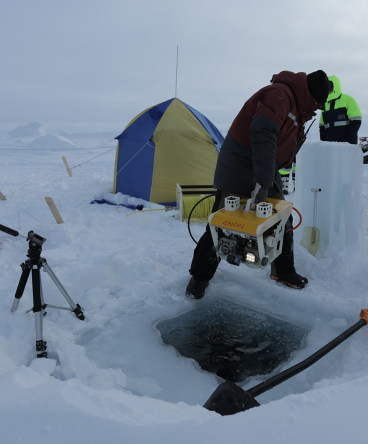
Figure 3. ROV “SuperGNOM Pro” before diving.
STD-measurements are used to calculate acoustical velocities in the water on different levels to apply a correction for sonar.
At the third stage the sonar system is deployed, tested and set in the certain site (the hole drilled in sea ice). During the test, the corrections are introduced to acoustic velocities (in order to control variations of acoustic velocities on the level of survey) and magnetic deviation. This requires vertical profile data of acoustic velocity (up to 100 m) based on sonar or ROV detection. Operation from a drift ice requires calibration of compass of the sonar system every time before diving. While operating on landfast ice it is sufficient to make calibration once after change of study area.
We aimed at the development of operating procedure of surveying ice-bottom surface, for this purpose the duration of each survey varied from an hour to two hours, with 2 surveys per location. Each diving point was later referred to a plan by tacheometric survey and arranged in an integrated dataset. Sonar surveying of a polygon usually took at least 2 days depending on extension (up to 120 m), mass of an object, ice thickness (up to 1 m), and transport availability for transportation of the sonar system.
The fourth stage involves processing of ROV-data. ROV-surveying data are edited for viewing and provided with explanatory comments. It usually takes not less than 4 hours to view and edit a one-hour survey.
The results of the sonar survey are prescreened to detect errors and recorded on the external media for further processing. Data processing requires special software to extract data on ice-bottom depth distribution, which are georeferenced to the horizontal local coordinate system.
The use of sonar system at the research station “Cape Baranov”
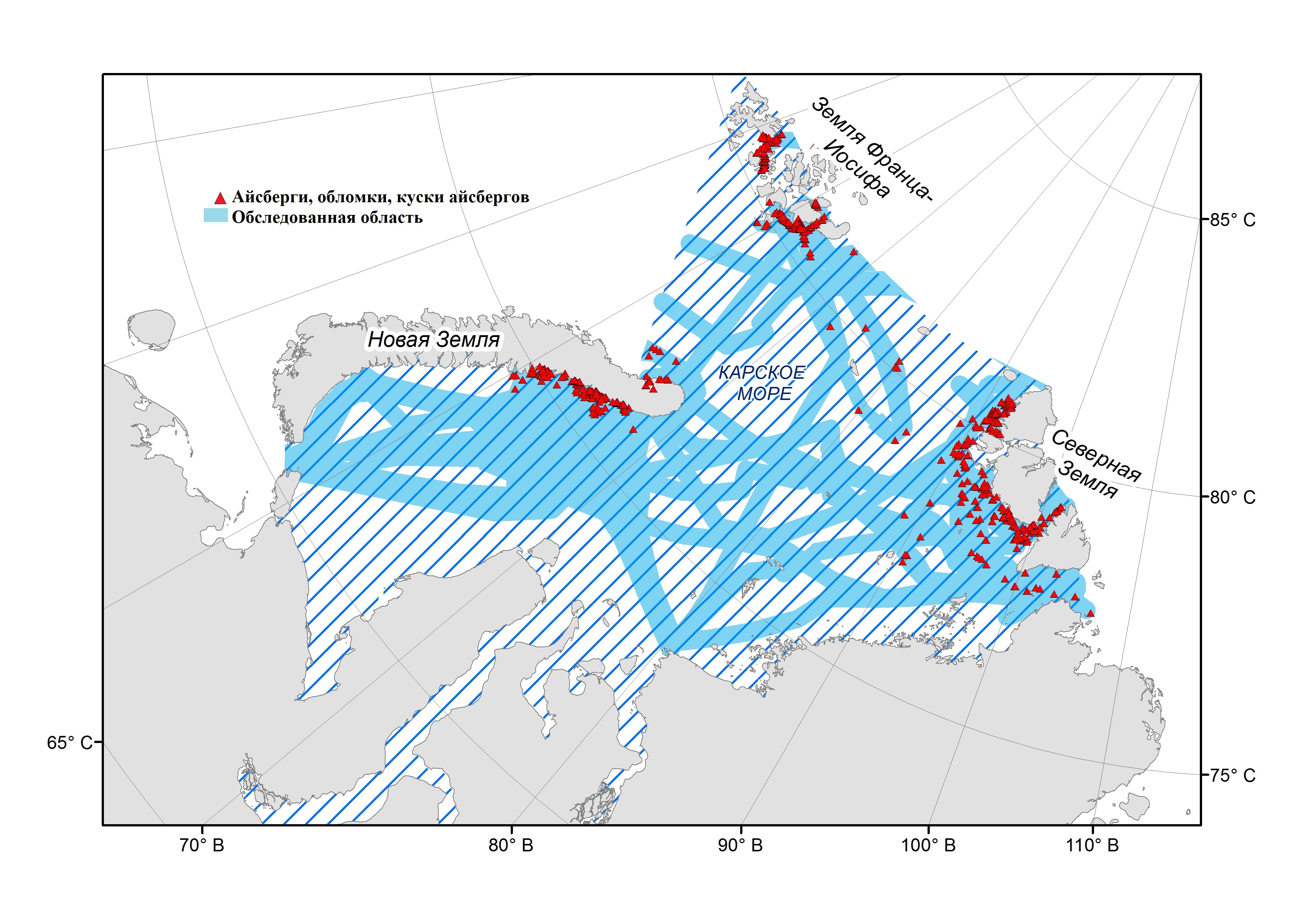
We use polar research station “Ice base Cape Baranov” as a testing site for developing the methodology of integrated ice detection by sonar system. The research station is situated on the high coast of the eastern tip of Bolshevik Island (part of the Severnaya Zemlya Archipelago) southward of Cape Baranov, facing the Shokalsky Strait. Geographic coordinates of the station are 79°17’N, 101°37’E [6]. There is Mushketov glacier nearby the station and Semyonov-Tyan-Shansky Glacier southward of the station. There is usually a huge amount of icebergs of medium size, bergy bits and growlers frozen in landfast ice. Fast ice edge is not far from the coast, further it is a zone of drift ice. Hummocking and ridging are the result of dynamic processes. In the north of Shokalsky Strait there is a flaw polynya with ice-free spaces or new ice.
During the season of April-May 2016 we identified a part of an iceberg using sonar system (Figure 4). The iceberg was located within landfast ice at a distance of 2.5 km from the coastline on the 22 m-isobath. Keel of the iceberg touched the bottom; seabed was covered by gouges. Total operating time of the sonar at the site was 4 days. We made integrated survey from four points. Processing of data of sonar detection from several locations was made by specialized software WIN881A Digital Sonar, the results were presented as a point cloud in local coordinates.
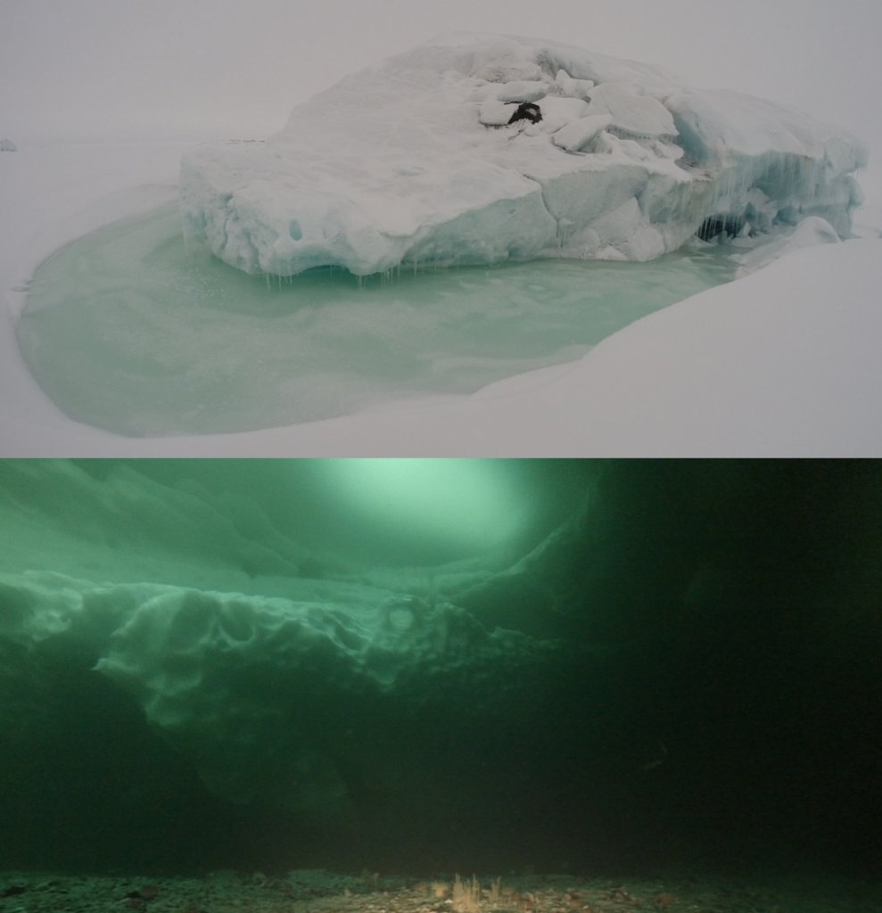
Figure 4. Above-water and underwater parts of the iceberg
We used specialized software Surf3D for georeferencing of all sonar data to the unified local coordinate system, extracting and deleting seabed features data and creating txt-files of 3-dimensional coordinates of ice-bottom surface. Georeferencing of the underside topography of iceberg associated with its surface topography (Figure 5) was made with use of the Golden Software Surfer.
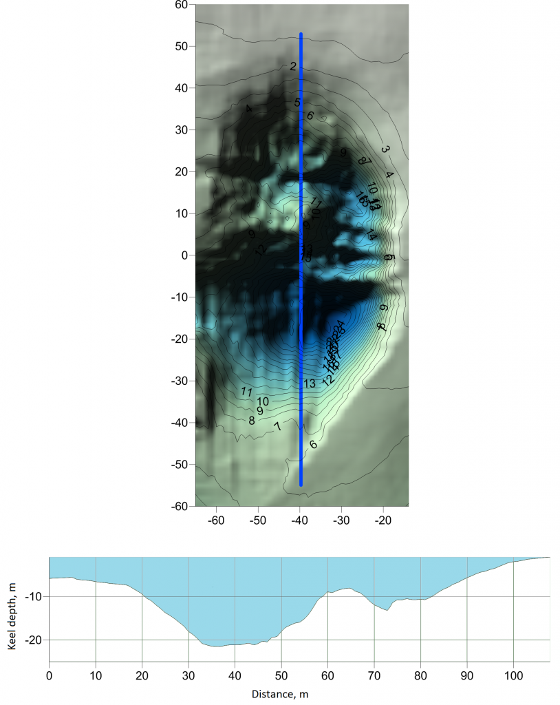
Figure 5. Ice-bottom topography of the iceberg based on sonar data.
During the seasonal research of March-April 2018 we detected an ice ridge formed in the zone of interaction of landfast ice and drift ice during freezing. Sonar survey lasted for one day and was made from one site from the side of the coast. At the same time thermal drilling was carried out to provide ice density data at nodes on a regular grid. This density data was used later to improve data on keel depth.
Sonar data were processed in the specialized software Surf3D and resulted in txt-files containing 3-dimensional coordinates of bottom surface of the ice ridge and surrounding area in local coordinates. We used Golden Software Surfer to plot ice-bottom topography chart (Figure 6).
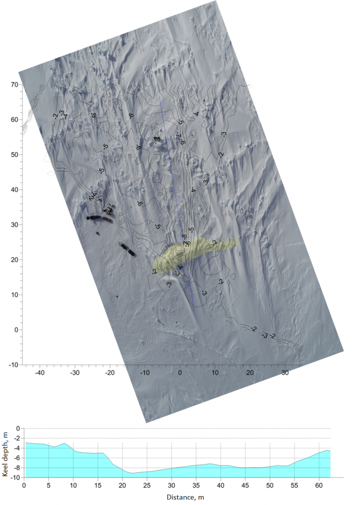
Figure 6. Chart and underside topography of the ice ridge
Application potential
We compared classical approaches of measuring morphometric characteristics of ice ridges, icebergs and level ice (mechanical drilling, thermal drilling) with data of sonar detection to develop general procedure of identifying the following characteristics of hummocks and ice ridges: volume, mass, internal structure, distribution of mass, strength, temperature and salinity inside the ice [7].
Using of sonar surveying both as a part of integrated approach and individually provides high measurement accuracy of linear characteristics of ice-bottom (underwater) surface at a certain area, which is equal to accuracy of above-water part of ice measured by modern methods (GPS-systems and electronic total stations).
References:
2. Smirnov V.N., SHushlebin A.I., Kovalyov S.M., SHejkin I.B. Metodicheskoe posobie po izucheniyu fiziko-mekhanicheskih harakteristik ledyanyh obrazovanij kak iskhodnyh dannyh dlya raschyota ledovyh nagruzok na berega, dno i morskie sooruzheniya. SPb. AANII.2011,178 s.
3. Morev V.A., Morev A.V., Haritonov V.V. Sposob opredeleniya struktury torosov i stamuh, svojstv l'da i granicy l'da i grunta. Patent na izobretenie № 2153070 ot 20.07.2000
4. SP 11-114-2004. Inzhenernye izyskaniya na kontinental'nom shel'fe dlya stroitel'stva morskih neftegazopromyslovyh sooruzhenij. Gosstroj Rossii. M.: Proizvodstvennyj i nauchno-issledovatel'skij institut po inzhenernym izyskaniyam v stroitel'stve (FGUP «PNIIIS») Gosstroya Rossii, 2004, 88 s.
5. Yevgeny U. Mironov, Roman B. Guzenko, Viktor S. Porubaev, Victor V. Kharitonov, Stepan V. Khotchenkov and Aleksandr V. Nesterov Morphometric Parameters of Stamukhas in the Laptev Sea, , International Journal of Offshore and Polar Engineering, ISOPE-2019, Honolulu, Hawaii, USA, 2019.
6. Itogi rabot na NIS «Ledovaya baza «Mys Baranova» v period oktyabr' 2016 –sentyabr' 2017 gg. Available at: http://www.aari.ru/news/text/2017/%D0%9D%D0%98%D0%A1%20%D0%9C%D0%91%202017%20%D0%B8%D1%82%D0%BE%D0%B...
7. Sposob opredeleniya fiziko-mekhanicheskih i morfometricheskih harakteristik ledovyh torosistyh obrazovanij. FIPS, Moskva; Zayavka na patent 2019133637 ot 22.10.2019.
This is an open access article distributed under the terms of the Creative Commons Attribution License (CC-BY 4.0)

