Abstract
In May-June 2020 two early transits through the Northern Sea Route to the east were made by LNG carriers «Christophe de Margerie» and «Vladimir Voronin». The first voyage was accompanied by the nuclear icebreaker «Yamal» all the way down, the second voyage «Vladimir Voronin» covered independently. In this paper, on the example of the pair «Christophe de Margerie» and «Vladimir Voronin» and one more pair «Georgy Brusilov» and «Vladimir Rusanov», followed the pioneer tankers a month later, it was analyzed two types of navigation: independent and with an icebreaker escort. The results of the analysis did not reveal sufficient differences in time and velocity of tankers, navigating independently or under icebreaker escort in those ice conditions, which had developed by the beginning of summer navigational season.
Keywords: LNG-carriers of type Yamalmax, nuclear icebreakers, ice class Arc7, Northern Sea Route, Arctic summer navigation, hydrometeorological data provision
Beginning of spring navigation in 2020
Summer navigation along the Northern Sea Route (NSR) in eastward direction usually begins in July [1], when melting and destructive processes in sea ice are observed.
On May 31, 2020 the liquefied natural gas (LNG) carrier Christophe de Margerie owned by Russian company ‘Sovcomflot’ successfully completed its voyage along the NSR. For the first time a large capacity Arc7 class vessel made such an early voyage to the eastern Arctic. The carrier was escorted by nuclear icebreaker (IB) Yamal. In a few days, on June 2, 2020, another very early voyage of LNG carrier Vladimir Voronin was completed. The main peculiarity of this voyage was independent navigation of Vladimir Voronin along the 70% of the route, including the most complicated leg in the East Siberian Sea. The carrier was provided by full meteorological information along the entire route. These two very early voyages formed a basis for the possibility of prolonged navigation windows along the NSR in eastward direction. Besides, Yamalmax class vessels Christophe de Margerie and Vladimir Voronin have demonstrated great icebreaking capability moving both ahead an icebreaker and independently.
The two LNG carriers sailed more than 2500 nautical miles (hereinafter ‘miles’) within different time periods: it took 12.5 days at average speed of 8.2 knots for Christophe de Margerie and 9.4 days at average speed 11.0 knots for Vladimir Voronin, respectively. Thus, expectations on higher speed of Christophe de Margerie under icebreaker assistance along the entire route as compared to the speed of Vladimir Voronin under icebreaker escort (50 let Pobedy and Yamal) on the part of the route was not confirmed.
This paper analyses the motion of both LNG tankers Christophe de Margerie and Vladimir Voronin in order to identify the impact of icebreaker assistance on speed and sailing time within the NSR for the Arc7 Yamalmax class LNG carriers, with other conditions being equal (i.e. movement start time, shipping route and associated ice conditions). Ice conditions were not always the same along the routes of Christophe de Margerie and Vladimir Voronin, as their tracks sometimes diverged significantly. For this reason, another two LNG carriers Vladimir Rusanov and Georgiy Brusilov were involved in comparison of assisted and independent navigation through ice. These carriers sailed in eastward direction within two days (June 29 and 30, 2020) in a month after Christophe de Margerie and Vladimir Voronin along the identical routes.
Yamalmax class LNG carriers
Yamalmax is a class of LNG carriers developed for transportation of liquefied natural gas in the Arctic. The lead LNG tanker Christophe de Margerie was built in 2016 [2], and was accepted into service by ‘Sovcomflot’ in March 2017 [3] after successful ice trials in the Arctic [4]. During the next three years another 14 LNG carriers were built to service ‘Yamal LNG’ project, including Vladimir Voronin, Vladimir Rusanov and Georgiy Brusilov.
Yamalmax class LNG tanker has length of 299 m, beam of 50 m, cargo capacity of more than 170 000 m3 and deadweight of more than 140 000 tones. The propulsion system consists of three Azipod full revolving propulsion units, delivering a total power of 45 MW. Arc7 ice class vessels are able to move both head-on and stern-first (double acting ship). Specific icebreaking capability while moving head-on and stern-first is 1.5 m and 2.1 m, respectively [2], [5].
For two years, from autumn of 2017 until winter of 2019, Yamalmax class carriers sailed along the NSR independently. Icebreaker assistance was carried out only in seaway canal in the north of the Gulf of Ob. All voyages of Yamalmax class tankers were provided by full meteorological support. During this period, both very late (in January) [6] and very early (in May) independent voyages were carried out [7].
In May, 2020 Christophe de Margerie surpassed the previous record of very early voyage by LNG carriers Vladimir Rusanov and Eduard Toll for more than a month, since in 2018 Vladimir Rusanov and Eduard Toll left the port of Sabetta on June 25 and 27, respectively. It took approximately 9 days to travel the entire length of the NSR for Vladimir Rusanov and Eduard Toll [7].
The first independent transit from east to west along the NSR without icebreaker assistance during winter navigation was made by Eduard Toll. On December 24, 2017 Eduard Toll entered the NSR and completed its transit voyage in 22 days, arriving at the port of Sabetta on January 14, 2018 [6].
Another significant event took place between 2018 and 2019. The LNG carrier Boris Davydov assisted the less powerful tanker Boris Sokolov (22 MW) along the NSR in western direction within winter navigation season. Boris Sokolov entered the NSR on December 29, 2018 and slowed down its moving due to presence of sea ice. On the night of January 2, 2019 Boris Sokolov went adrift awaiting the LNG carrier Boris Davydov. On January 5, Boris Davydov came to the point of drift of the tanker and carried out ice escort. On January 23, 2019 (18 days later) the convoy entered the Gulf of Ob, afterwards Boris Sokolov continued moving independently to Murmansk [8], [9].
Since 2017 the Yamalmax class carriers, therefore, have demonstrated ability both of independent navigation in difficult sea ice conditions and providing the icebreaker assistance of less powerful vessel in ice.
Sea ice conditions at the beginning of summer navigation season
Sea ice conditions in the Arctic seas at the end of May were favourable for early navigation.
Sea ice formation in previous autumn season of 2019 began later than long-term average (at the beginning of September). Later on, in November and December, both the intensity of ice formation and the ice extent increased significantly, though growth of ice thickness was below normal.
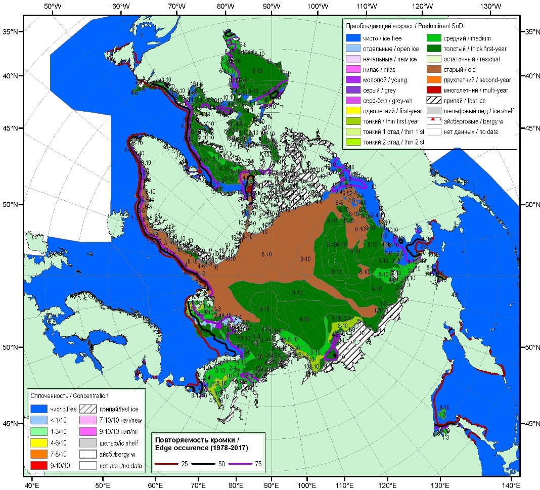
In January, all the Arctic seas were covered by drifting and fast ice. Predominance of medium first-year ice (70-120 cm according to the Nomenclature of sea ice [10], [11]) over a significant area was observed only in the Laptev Sea and East Siberian Sea. Thick first year ice (more than 120 cm) was scarce. The observed absence of zones with predominance of thick first year ice both in February and March was unusual for these months, revealing the delay in growth of ice cover.
Fast ice formation during the first winter months was of low intense over all the Russian Arctic seas. Fast ice extent was below long-term average values in all seas [12].
In April, transformation of medium first year ice to thick first year ice began in most of the Arctic seas, except the Kara sea and Chukchi Sea, where medium and thin (30-70 cm) first year ice were predominant. Sea ice growth delayed significantly as compared to normal within spring season of 2020.
During the period of maximum ice development and ice concentration in May, first year ice covered the entire Russian Arctic and more than half of the circumpolar area, partly displacing multi year ice. Fast ice extent was low at the end of this period; it was developed mostly in the vicinity of New Siberian Islands. However, fast ice extent remained below the long-term average values.
Throughout the spring season, the intensity of ice growth was somewhat above normal in the Laptev Sea and East Siberian Sea, resulted in ice thicknesses close to average values which are specific to these regions. In the western Arctic seas negative abnormalities of sea ice thickness remained (up to 50 cm).
In June, rapid sea ice retreat began in the western Arctic seas (Barents Sea, Kara Sea and Laptev Sea), as well as the large area of open floating ice was developed in the south-western Chukchi Sea. Ice formation stopped in all seas [13].
At the end of winter season and at the beginning of summer season (March-May), ice extent was close to the average values in the Arctic Ocean, while it declined significantly with beginning of melting, as compared to long-term average extent (Fig. 1). Sea ice thickness was notably below normal over the entire Arctic Ocean, which is proved by model calculations of the Arctic sea ice volume (Fig. 2) [14].
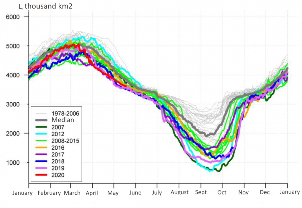
Figure 1. Daily estimations of seasonal cycle of ice extent for the period 26.10.1978–17.05.2020 from 95E to 170W (Laptev Sea – Chukchi and Bering Sea, Sea of Okhotsk) [14].
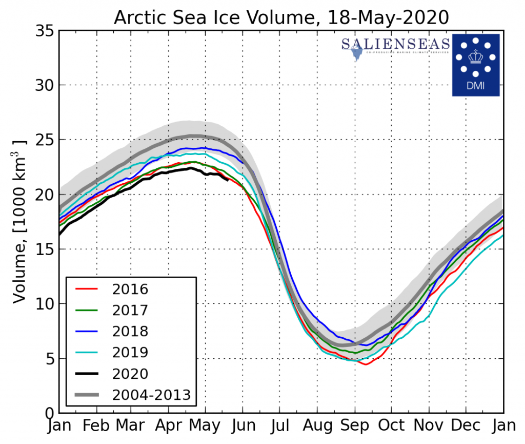
Figure 2. Daily estimations of seasonal cycle of Arctic sea ice volume for the period 01.01.2004–18.05.2020, based on calculated weighted average ice thickness using operational ocean and sea ice model HYCOM/CICE by Danish Meteorological Institute [15].
Data and method of analysis
Following data were used to analyze motion of LNG carriers:
AIS (Automated Identification System) data on vessel location, characteristics of movement (speed, direction, time) along the entire route from departure from the port of Sabetta till exit from the NSR for 4 LNG carriers (Christophe de Margerie, Vladimir Voronin, Vladimir Rusanov and Georgiy Brusilov) and 2 icebreakers (Yamal, 50 Let Pobedy )
Ship reports from LNG carriers and icebreakers, describing ice conditions along the shipping route within the NSR
General ice charts of all the Arctic seas by AARI
Satellite images in visible, infrared and radio range
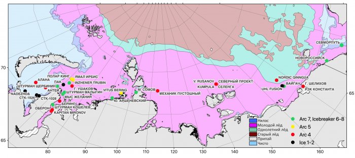
AIS data were used for building shipping routes (Fig. 3), each of it was divided into 5 legs: 1 – south-western Kara Sea (areas of the Gulf of Ob, Yenisey Gulf and Pyasino Gulf), 2 – north-eastern Kara Sea, 3 – Laptev Sea and New Siberian Islands, 4 – western and central East Siberian Sea, 5 – eastern part of the East Siberian Sea and Chukchi Sea. For every leg the following characteristics were calculated: average speed, voyage time, prevailing ice conditions.
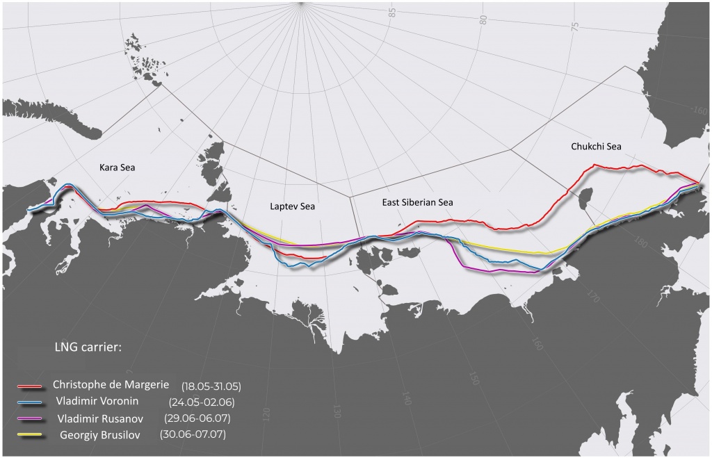
Figure 3. Shipping routes of LNG carriers Christophe de Margerie, Vladimir Voronin, Vladimir Rusanov and Georgiy Brusilov
Prevailing ice conditions included sea ice age and ice concentration and were based on ice charts. Data on additional characteristics, such as fracturing, hummocking and ridging, were taken from ship reports if available and sufficient for compilation.
Ship reports and satellite images were involved to analyze speed anomalies. For visual evaluation of speed variability of a ship or a convoy, 6 classes of speed were identified: up to 2 knots, 2-4, 4-8, 8-12, 12-16 and more than 16 knots.
Discussion
Data processing resulted in two tables (Table 1 and Table 2) for pairs Christophe de Margerie-Vladimir Voronin and Vladimir Rusanov-Georgiy Brusilov with generalized characteristics of their movement.
Table 1. Motion characteristics and generalized characteristics of ice conditions for LNG carriers Christophe de Margerie and Vladimir Voronin
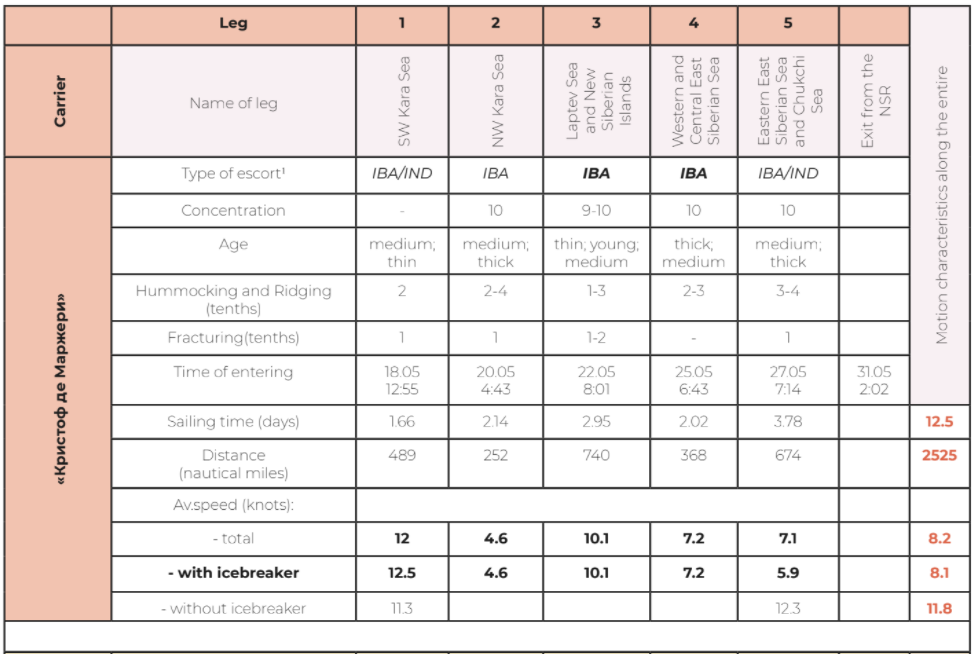
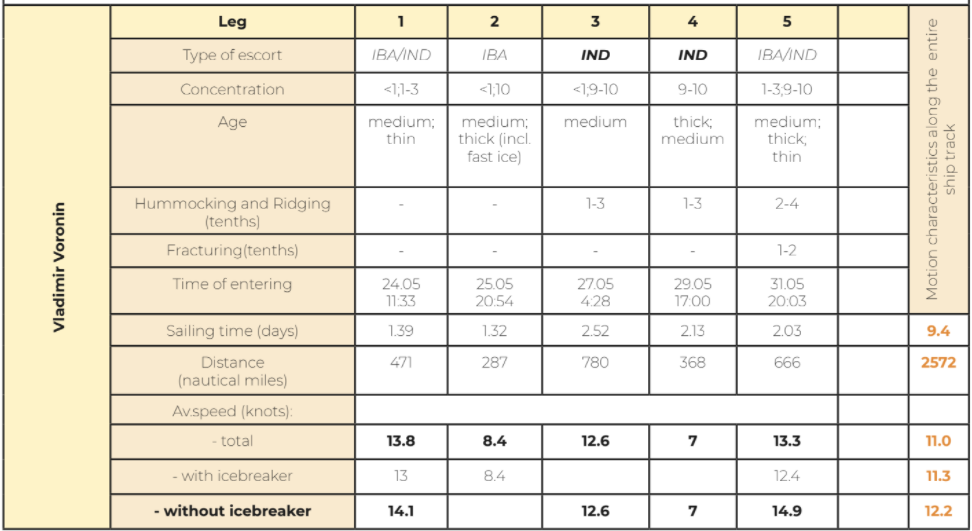
1Type of escort: IBA – motion with icebreaker assistance, IND - independent navigation, IBA/IND – combination of independent;
Table 2. Motion characteristics and generalized characteristics of ice conditions for LNG carriers Vladimir Rusanov and Georgiy Brusilov
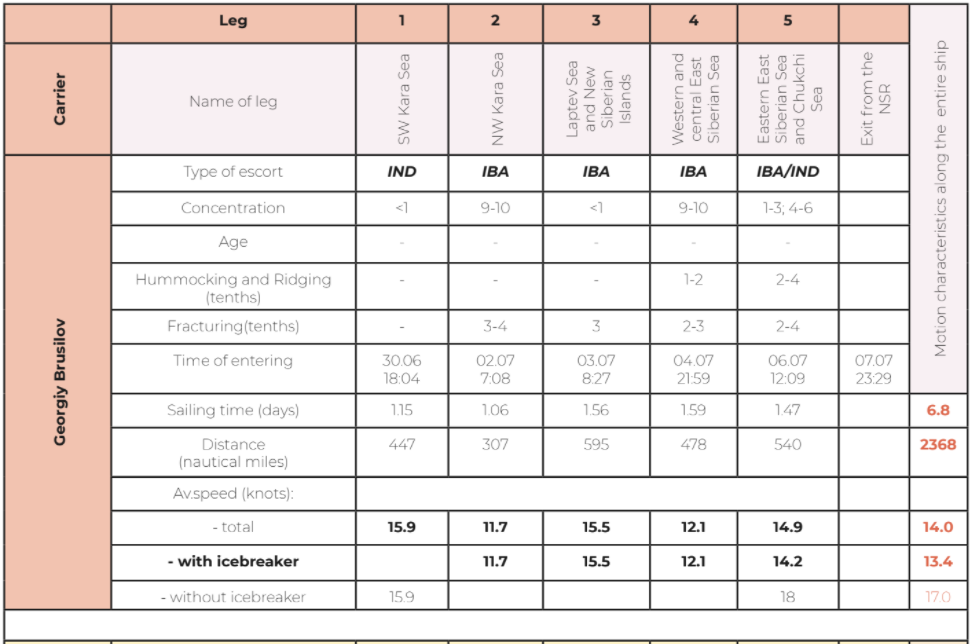
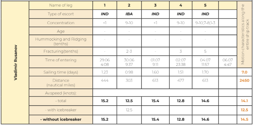
Calculations presented in the tables show, that average speed and voyage time for Christophe de Margerie and Vladimir Voronin differ significantly. Christophe de Margerie sailed the NSR for 12.5 days at average speed of 8.2 knots under icebreaker assistance along the entire route, since Vladimir Voronin traveled for 9.4 days at average speed of 11.0 knots, sailing primarily independently. Average characteristics of another pair Vladimir Rusanov – Georgiy Brusilov are slightly different. Georgiy Brusilov traveled for 6.8 days at average speed of 14.0 knots under icebreaker assistance, while predominantly independent eastward voyage of Vladimir Rusanov took 7.0 days with average speed of 14.1 knots.
Peculiarities of the shipping routes of every pair of the carriers are considered in more detail individually for each leg of the route.
Christophe de Margerie - Vladimir Voronin
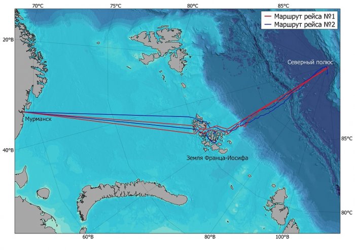
LNG carrier Christophe de Margerie left the port of Sabbetta on May 18, 2020. On May 19, 2020 the carrier met IB Yamal and started navigation under assistance at the exit of the Gulf of Ob. Vladimir Voronin departed from Sabetta 5.5 days later, on May 24, 2020. Meeting with IB 50 Let Pobedy and beginning of escort took place on May 25, 2020 abeam the Pyasina Bay (Fig. 4). Ice conditions along the NSR had changed insignificantly to the moment of departure.
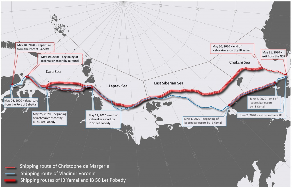
Figure 4. Shipping routes of LNG carriers Christophe de Margerie and Vladimir Voronin and icebreakers Yamal and 50 Let Pobedy.
During the voyage of Christophe de Margerie ice trials were planned to carry out in the Kara Sea and Laptev Sea. The trials did not influence significantly average speed of the carriers, thus they may be neglected.
Main difference in average speed was due to alternative routes, which diverged for several times and, hence, showed different ice conditions (Fig. 5 and 6); this fact allowed to reduce time lag between Christophe de Margerie and Vladimir Voronin to three days. The diverged legs of the routes were in the north-western Kara Sea, eastern part of the East Siberian Sea and Chukchi Sea. Sea ice conditions throughout each leg of route are considered in more detail.
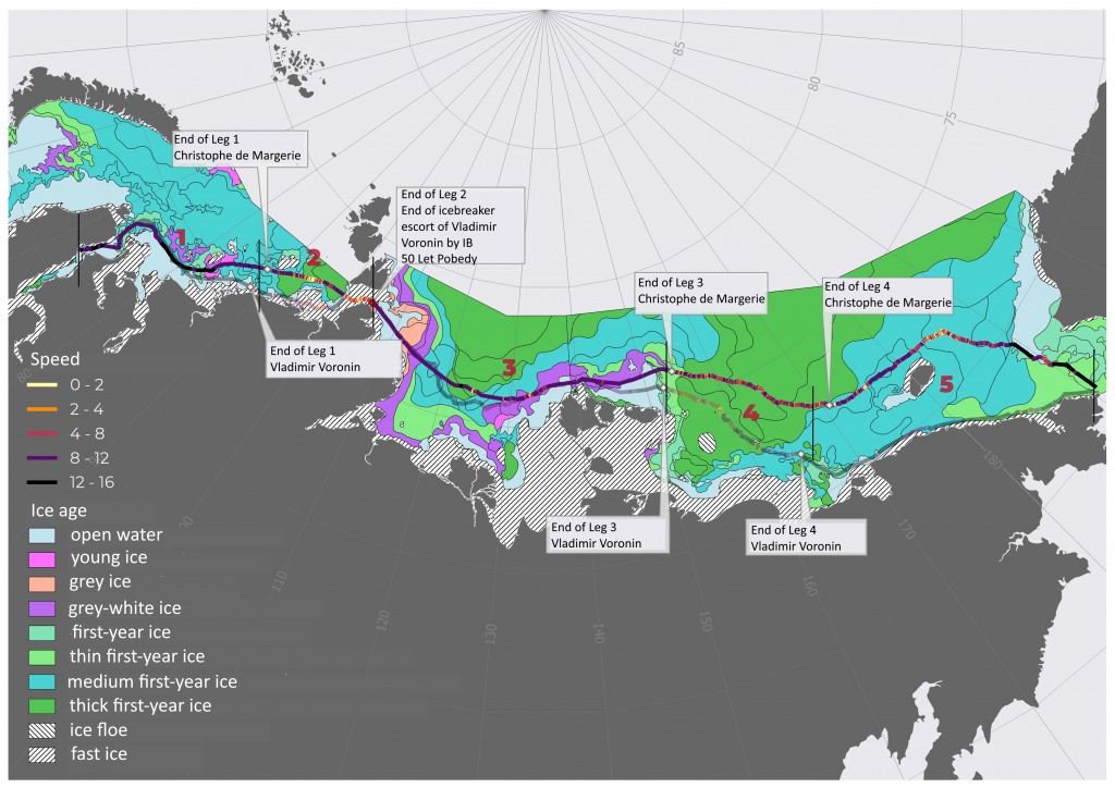
Figure 5. Ice conditions in the Arctic seas along the NSR during the eastbound sail of Christophe de Margerie and the shipping route with indication of speed. Shipping route of Vladimir Voronin is semitransparent. 1-5 are numbers of legs for comparison.
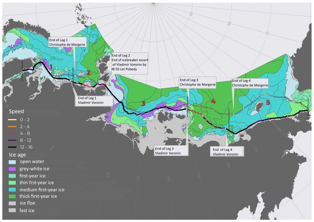
Figure 6. Ice conditions in the Arctic seas along the NSR during the eastbound sail of Vladimir Voronin and the ship track with speeds. Shipping route of Christophe de Margerie is semitransparent. 1-5 are numbers of legs for comparison.
Over the first leg of route (1 – south-western Kara Sea) the LNG carriers sailed both independently and under icebreaker assistance. Ice conditions did not obstruct the independent navigation of the carriers. Sea ice in the south-western part of the Kara Sea began to retreat, the shipping routes passed open water areas (<1 tenths) and areas of very open floating ice (1-3 tenths). In vicinity of the Sverdrup Islands the tracks diverged.
The second leg (2 – north-eastern Kara Sea) started abeam the Kirov Islands; the carriers navigated in different ice conditions. Christophe de Margerie operated in thick and medium first year ice (Fig. 7). According to ship reports, the carrier had to stop its movement repeatedly awaiting the icebreaker to pass through hummocked ice or form a navigable canal. The convoy entered fast ice in Vilkitsky Strait on May 21, 2020. Average speed of forming navigable canal by icebreaker in fast ice was about 4 knots. Christophe de Margerie entered open water in the Laptev Sea in 17.5 hours.
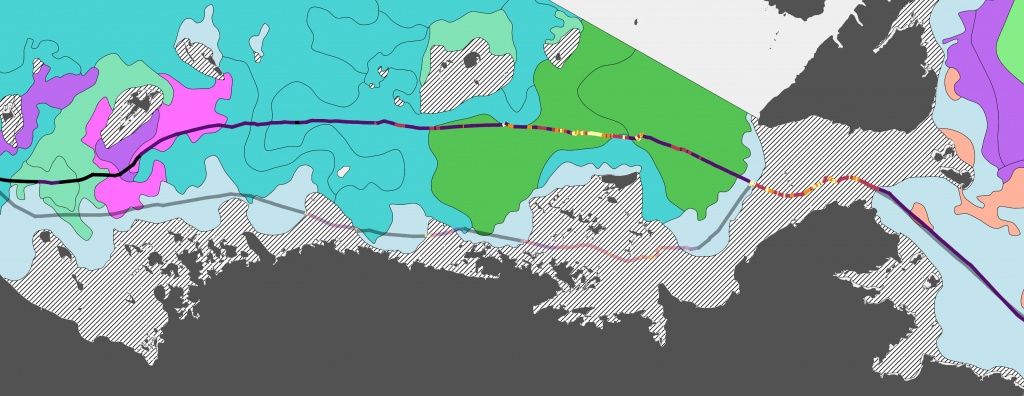
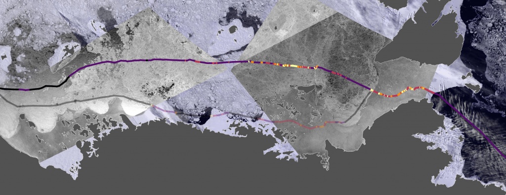
Figure 7. Ice chart for May 17-18 (left). Image mosaics derived from MODIS spectroradiometers (Terra) and Sentinel-1 satellite radar on May 20, 2020 (right). Shipping route of Christophe de Margerie (the route of Vladimir Voronin is highlighted semitransparent).
The route of LNG carrier Vladimir Voronin under assistance of IB 50 Let Pobedy passed primarily along the continental coastline, crossing the areas of very open floating first year ice, as well as fast ice (Fig. 8). The convoy passed Vilkitsky Strait through the navigable canal formed earlier by IB Yamal at average speed of 10 knots. Therefore, Vladimir Voronin sailed the second leg at average speed of 8.4 knots, while average speed of Christophe de Margerie was 4.6 knots. Comparison shows that the carriers were not in equal conditions over this part of the route. Another reason to eliminate this leg from comparison is support by icebreakers.
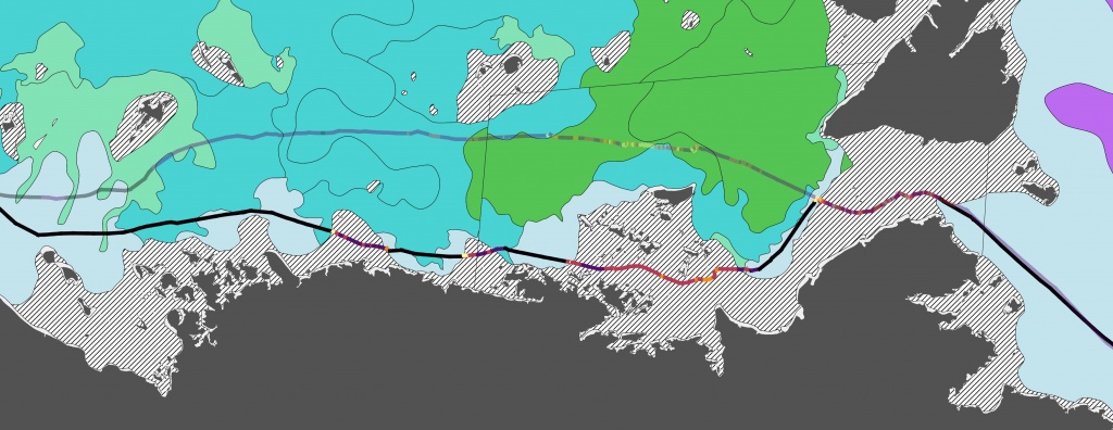
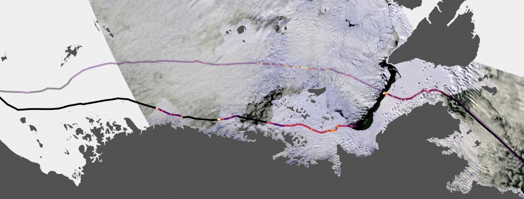
Figure 8. Ice chart for May 21-22 and May 26 (left). Image mosaics derived from MODIS spectroradiometers (Terra) and VIIRS (Suomi-NPP) on May 26, 2020 (right). Shipping route of Vladimir Voronin (the route of Christophe de Margerie is semitransparent).
Christophe de Margerie and Vladimir Voronin passed the longest third leg (3 – Laptev Sea and New Siberian Islands) at average speed of 10.1 and 12.6 knots, respectively. Vladimir Voronin continued the way independently after its exit from Vilkitsky Strait. Light ice conditions in the Laptev Sea allowed both carriers to pass it without significant problems. Figures 9 and 10 show, that almost all over the leg the routes of both carriers coincided, excepting the part of route in the central Laptev Sea, where the route of Vladimir Voronin lay to the south of the route of Christophe de Margerie in order to avoid a tongue of thick first year ice, expanded from the north. According to expert assessments, concentration of thick first year ice was from 5 to 8 tenths at the time of passing this part of the route by the carriers. Speed loss happened on certain short distances, while observed ridging and hummocking was up to 3 tenths according to the ship reports by Christophe de Margerie. Avoiding the area of thick first year ice by passing it from the south resulted in increased total length of the third leg for almost 100 miles, though provided Vladimir Voronin for independent navigation through the central Laptev Sea at speed about 2 knots higher than those of Christophe de Margerie under icebreaker Yamal assistance. Besides, Vladimir Voronin passed through open water in the western Laptev Sea at a higher speed (14.5 knots), as compared with Christophe de Margerie (11.5 knots).
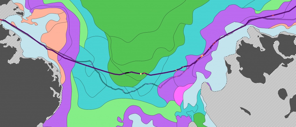
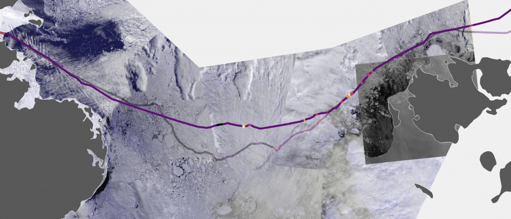
Figure 9. Ice chart for May 19-20 (left). Image mosaics derived from VIIRS (Suomi-NPP) on May 22-24, 2020 (right). Shipping route of Christophe de Margerie (the route of Vladimir Voronin is semitransparent).
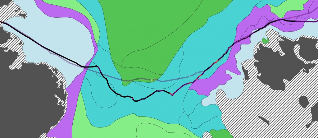
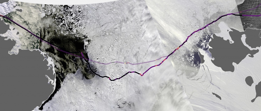
Figure 10. Ice chart for May 25-26 (left). Image mosaics derived from MODIS (Terra) and VIIRS (Suomi-NPP) on May 29, 2020 (right). Shipping route of Vladimir Voronin (the route of Christophe de Margerie is semitransparent).
The next leg 4 of the route (western and central East Siberian Sea) was specified by the most difficult ice conditions. Although only first year ice was presented along the tracks of Christophe de Margerie and Vladimir Voronin, ice characteristics, particularly ice thickness, varied throughout the route. This was due to various time and conditions of ice formation in different part of the sea.
Ice formation in the open sea began in the mid-October. To the end of October, the entire central part of the sea was covered with sea ice, as well as the straits of the New Siberian Islands, while north-western and eastern parts were still ice-free. Further development of ice conditions in winter season was affected by prevailing winds, providing heat supply and ice transport from Chukchi Sea to the center of East Siberian Sea in the eastern part, and inducing continuous ice offshore motion northward the New Siberian Islands in the western part (forming of recurring polynya). Afterwards, all of these factors contributed to difficult ice conditions in the central part and more light conditions in the eastern and western parts of the sea. In the eastern and western parts of the sea new ice formation occurred during winter season, as contrasted to the central part, where accumulation of sea ice, which had formed already in autumn, took place, as well as ice transport from the Chukchi Sea, followed by strong compacting and hummocking.
During the navigation of LNG carriers Christophe de Margerie and Vladimir Voronin across the East Siberian Sea, the area of New Siberian ice massif was a limiting factor. According to expert assessments, to the end of May, 2020 thick first year ice of 5-8 tenths prevailed along the route. Decrease of speed was primarily due to motion through hummocked floes of thick and medium first year ice (Fig.11, 12). Another factor, which complicated the navigation over this leg, was ice originated from pancake ice. Both carriers passed along this leg for approximately equal time with almost equal average speed (7.2 and 7.0 knots for Christophe de Margerie and Vladimir Voroni, respectively). At the beginning of the leg, average speed of the carrier Vladimir Voronin was about 5.0 knots; as moving to the south-east towards Ayon Island, average speed over the last part of the route increased up to 8.5 knots. As a result, Vladimir Voronin passed through lighter medium first year ice, while Christophe de Margerie continued its motion through difficult thick first year ice in the central part of the sea, moving to the north of Wrangel Island.
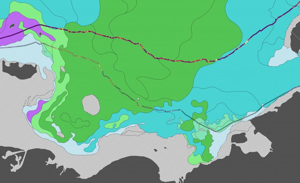
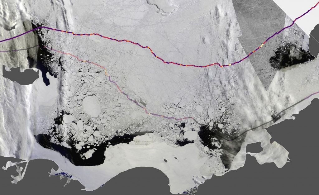
Figure 11. Ice chart for May 24-26 (left). Image mosaics derived from VIIRS (Suomi-NPP) and Sentinel-1 satellite radar on May 27, 2020 (right). Shipping route of Christophe de Margerie (shipping route of Vladimir Voronin is semitransparent).
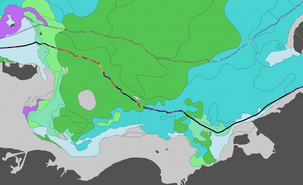
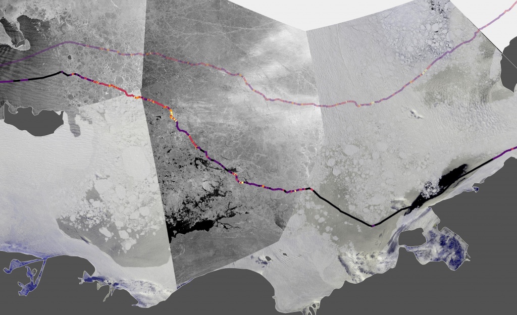
Figure 12. Ice chart for May 27-28 (left). Image mosaics derived from VIIRS (Suomi-NPP) on May 29 and June 1, 2020 and Sentinel-1 satellite radar on May 29 and 30, 2020 (right). Shipping route of Vladimir Voronin (shipping route of Christophe de Margerie is semitransparent).
Ice conditions were totally different over the leg 5 (eastern part of the East Siberian Sea and Chukchi Sea) of both shipping routes, as they lay in completely different parts of the East Siberian and Chukchi Seas (Fig.13). Vladimir Voronin reached continental shore, entered flaw polynya in vicinity of Chaunskaya Bay and completed the transit of the NSR almost unhindered. Christophe de Margerie had a lead of 4 days in the East Siberian Sea, when it followed the navigational recommendation to set a course to the north of Wrangel Island, as the Chukchi Polynya was not still observed. According to expert assessments, the Long Strait was completely blocked by very close floating medium and thick first year ice at the time of passing through by the carrier, therefore it was a risk for the carrier to become subjected to strong ice pressure. However, to the north-east of Wrangel Island in the Chukchi Sea, the convoy was beset repeatedly in very hummocked ice (3-4 tenths) and was subjected to repeated compression (1-2 tenths) due to strong southward wind resulted in ice compacting. The convoy passed this leg of the route of about 130 miles at average speed of 3.5 knots. As a result, about 1.5 days were lost.
Christophe de Margerie passed along the fifth leg of the route at average speed of 7.1 knots, while average speed of Vladimir Voronin was 13.3 knots. Another reason, that the leg is not representative for comparison, is that Vladimir Voronin, as well as Christophe de Margerie, operated under support of icebreaker Yamal over the most part of the leg.
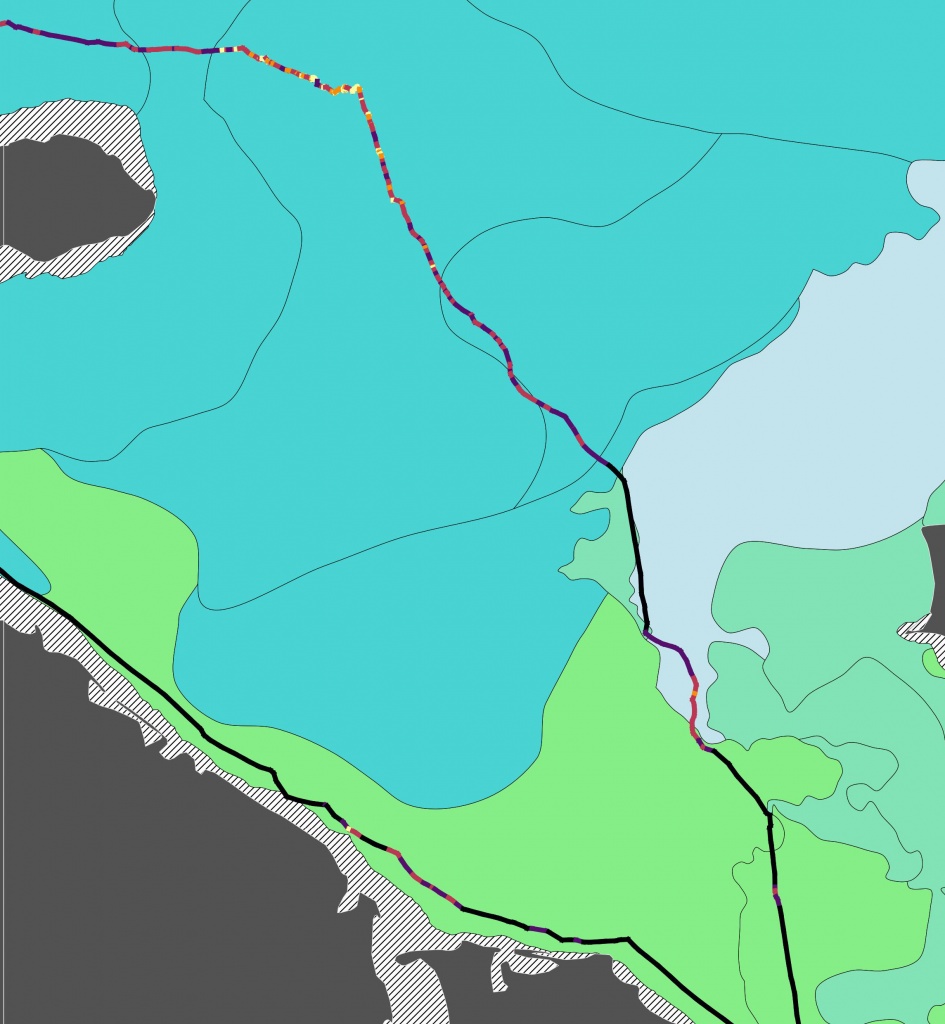
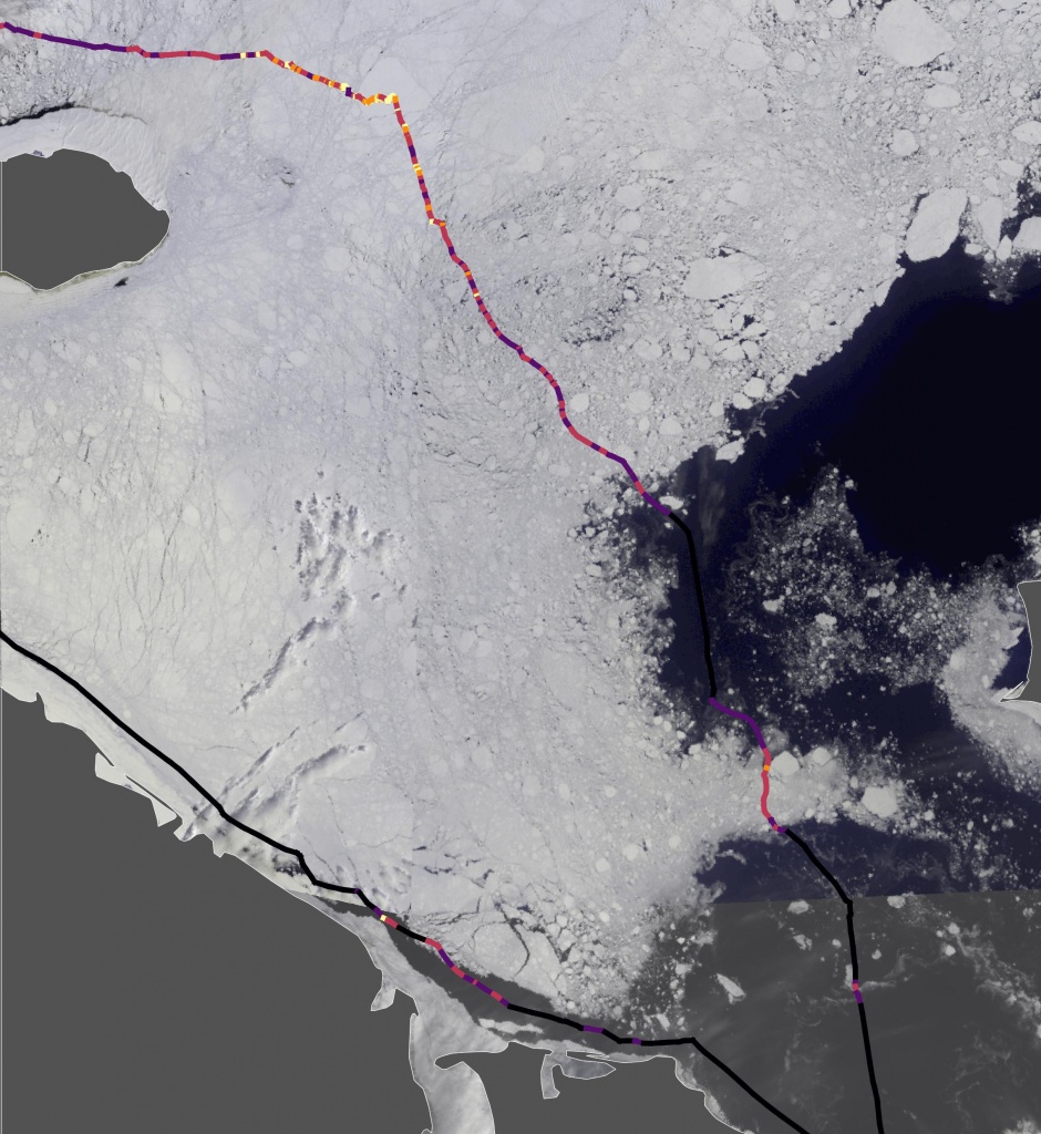
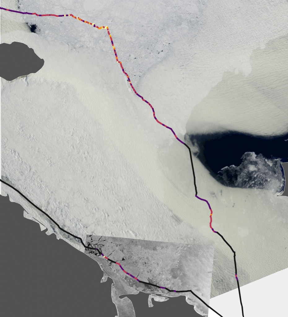
Figure 13. Ice chart for May 26-28, 2020 (left). Image mosaics derived from VIIRS (Suomi-NPP) on May 27 and 30, 2020 (center). Image mosaics derived from MODIS (Terra) on June 1, 2020 and Sentinel-1 satellite radar on June 2, 2020 (right). Shipping routes of Christophe de Margerie (northwards of Wrangel Island) and Vladimir Voronin (along the continental coastline).
Analysis of motion of this pair of LNG carriers demonstrates, that it is improperly to intercompare average speeds of both carriers, since ice conditions varied significantly over some parts of the routes. Of the five legs the routes were divided for, only the third and fourth legs can be compared. Average speed over these two legs was 8.7 knots for LNG carrier Christophe de Margerie and 9.8 knots for Vladimir Voronin, respectively.
Vladimir Rusanov – Georgiy Brusilov
In contrast to the previous pair of vessels, Vladimir Rusanov and Georgiy Brusilov departed within only 1.5 days of one another. Ship routes coincided on almost the entire way, except for the leg in the East Siberian Sea (Fig.14). The only unforced stop of Georgiy Brusilov, when it went adrift for 10 hours awaiting the icebreaker, was excluded from the analysis.
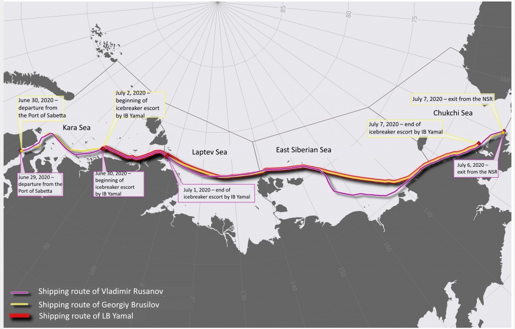
Figure 14. Shipping routes of LNG carriers Georgiy Brusilov and Vladimir Rusanov and IB Yamal
Vladimir Rusanov left the port of Sabetta in the early morning on June 29, 2020, while Georgiy Brusilov departed the next evening on June 30, 2020. Meeting with IB Yamal in both cases took place in the similar point to the north-west of the Pyasino Gulf.
At the beginning of the voyage, ice conditions offered no difficulties all over the NSR, which was proved by high speed of the LNG carriers along the entire route (Fig. 15 and 16). Minimal average speed on the leg was 11.7 knots, while maximal average speed was 15.9 knots. At the end of June, sea ice active melting and breaking took place over the all seas. North-eastern part of the Kara Sea, Laptev Sea and Chukchi Sea were half ice-free.
Coincidence of shipping routes and equal ice conditions allow comparison of average speed of the carriers along the entire route. Therefore, we do not present the detailed description of ice conditions for this case.
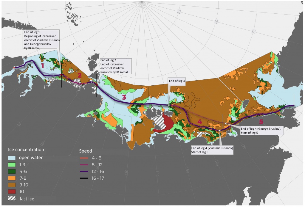
Figure 15. Ice conditions in the Arctic seas along the NSR during the eastward transition of the LNG carrier Vladimir Rusanov, the route and speed. The route of the LNG carrier Georgiy Brusilov is semitransparent. Symbols 1-5 are numbers of legs for comparison.
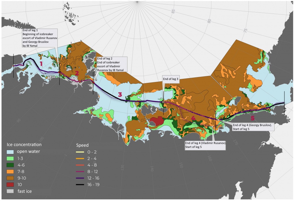
Figure 16 – Ice conditions in the Arctic seas along the NSR during the eastward transition of LNG carrier Georgiy Brusilov, the route and speed. Shipping route of LNG carrier Vladimir Rusanov is semitransparent. Symbols 1-5 are numbers of legs for comparison.
Vladimir Rusanov and Georgiy Brusilov sailed along the first leg independently at high speed, reaching 15.2 and 15.9 knots, respectively.
Both carriers passed along leg 2 of the NSR under icebreaker Yamal escort. Shipping routes lay along the continental coastline and passed through fast ice in the Matisen Strait. Fast ice was already broken in the Vilkitsky Strait to the moment of carriers passing through (Fig. 17, 18). At the exit of Vilkitsky Strait, only Vladimir Rusanov continued independent navigation. Average speeds over the second leg were 12.5 and 11.7 knots, respectively, for Vladimir Rusanov and Georgiy Brusilov.
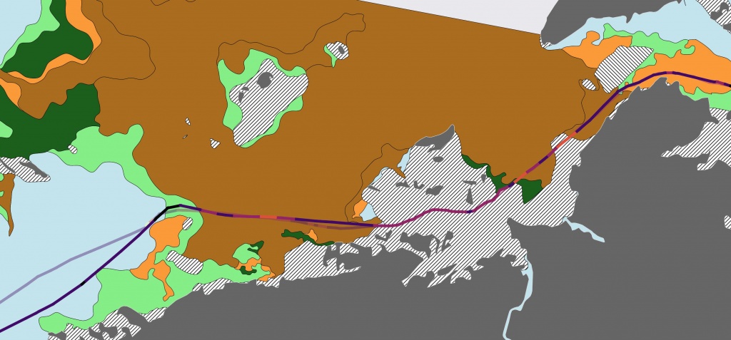
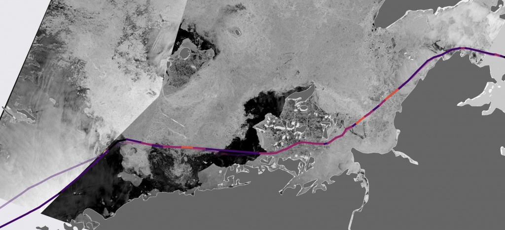
Figure 17. Ice chart for June 28-30, 2020 (left). Image mosaics derived from Sentinel-1 satellite radar on June 30 and July 1, 2020 (right). The route of LNG carrier Vladimir Rusanov (the route of LNG carrier Georgiy Brusilov is semitransparent)
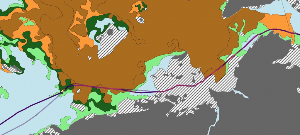
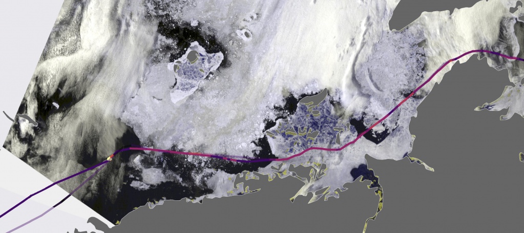
Figure 18. Ice chart for June 28-30, 2020 (left). Image derived from MODIS radiometer (Terra) on July 3, 2020 (right). Shipping route of Georgiy Brusilov (the route of Vladimir Rusanov is semitransparent)
Most of the way of the third leg in the Laptev Sea the carriers passed through the open water, following the same route with equal speed (15.5 knots for Georgiy Brusilov and 15.4 knots for Vladimir Rusanov). The carriers met with very open ice (1-3 tenths), open ice (4-6 tenths) and close ice (7-8 tenths) in the eastern part of the sea close by the New Siberian Islands (Fig.19).
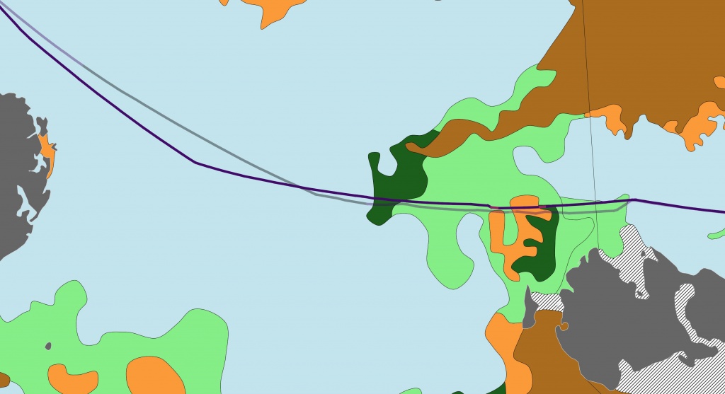
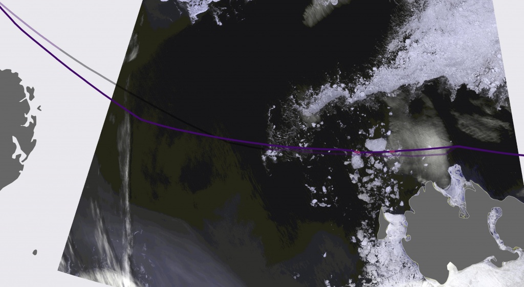
Figure 19. Ice chart for July 2-3, 2020 (left). Image derived from MODIS radiometer (Tera) on July 2, 2020 (right). Shipping route of Vladimir Rusanov (the route of Georgiy Brusilov is semitransparent)
Over the leg 4 in the East Siberian Sea the tracks diverged for the first time. Vladimir Rusanov turned to the south on the latitude of the island of Novaya Sibir and moved in this direction for 100 miles, than turned to the south-east towards Ayon Island and followed along the continental coastline till the exit from the NSR. After entering the East Siberian Sea and leaving the New Siberian Islands, Georgiy Brusilov and Yamal traveled in south-eastern direction across the central part of the sea. Both carriers passed through very close floating ice (9-10 tenths) over the most of the route, however, Vladimir Rusanov was first to enter the area of close floating ice (7-8 tenths) and open floating ice (4-6 tenths) (Fig.20). As a result, the average speed of Vladimir Rusanov over the forth leg was 12.8 knots, while Georgiy Brusilov passed the leg with average speed of 12.1 knots.
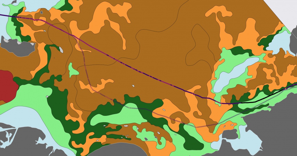
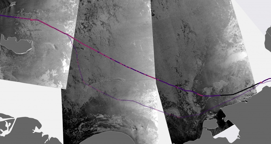
Figure 20 – Ice chart for July 4-6, 2020 (left). Image mosaics derived from Sentinel-1 satellite radar on July 4, 2020 (right). Shipping route of Georgiy Brusilov (the route of Vladimir Rusanov is semitransparent)
Both LNG carriers navigated the last fifth leg 5 through the polynya along the continental coastline. Vladimir Rusanov had slight reduction in speed to 8 knots due to meeting with small ice floes of hummocked fast ice. Georgiy Brusilov had longer distances with reduced speed. The convoy passed slightly north of Vladimir Rusanov shipping route through the area of very close floating ice (9-10 tenths) (Fig.21). This fact, however, had no effect on the average speed of Georgiy Brusilov over the entire leg, which was 14.9 knots (taking into account the part of the leg with independent sailing after the end of icebreaker support by IB Yamal), while average speed of LNG carrier Vladimir Rusanov was 14.6 knots.
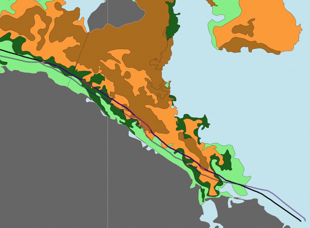
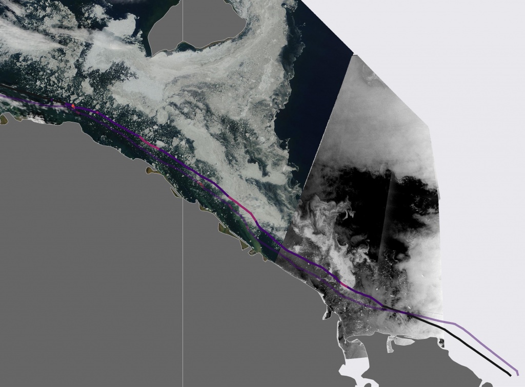
Figure 21. Ice chart for July 6-7, 2020 (left). Image mosaics derived from MODIS radiometer (Terra) and Sentinel-1 satellite radar on July 6, 2020 (right). Shipping route of Georgiy Brusilov (the route of Vladimir Rusanov is semitransparent)
Vladimir Rusanov transited along the entire NSR at average speed of 14.1 knots, while average speed of Georgiy Brusilov throughout the NSR was 14.0 knots. Excluding the second leg from the route of Vladimir Rusanov, where the carrier sailed under icebreaker escort of Yamal, would increase the speed to 14.5 knots. In case of deleting the parts of the route, where Georgiy Brusilov navigated independently (leg 1 and partly leg 5), the average speed would decreases to 13.4 knots. Thus, average speed of LNG carrier Vladimir Rusanov was higher in both cases. Nevertheless, Georgiy Brusilov traveled along the NSR faster (6.8 days), as compared to Vladimir Rusanov (7.0 days), which route was 80 miles longer.
Conclusion
LNG carrier Christophe de Margerie spent 12.5 days on the route under escort by IB Yamal (May 18 – 31, 2020), traveling 2525 miles at average speed of 8.1 knots (navigation only under icebreaker assistance). Sailing time of Vladimir Voronin was 9.4 days, it traveled 2572 miles at average speed of 12.2 knots (only independent navigation).
Comparison of independent operation of the carriers with navigation under icebreaker escort along the entire route is impossible due to difference in ice conditions over particular long-distance legs. Shipping routes were divided into 5 legs; based on the results of analysis, only 2 of them can be used for comparison: the Laptev Sea, including the New Siberian Islands, as well as western and central East Siberian Sea. Light ice conditions were developed along the leg in the Laptev Sea. Vladimir Voronin traveled the leg at average speed of 12.6 knots, which was 2.5 knots faster than Christophe de Margerie (10.1 knots), mainly due to both deviation of the route to the south in order to avoid more difficult ice and increasing the area of open water in the western part of the sea (since Vladimir Voronin departed 5 days later). The most severe ice conditions were in the East Siberian Sea. Both LNG carriers traveled on this leg at approximately equal speed of 7.2 knots (Christophe de Margerie) and 7 knots (Vladimir Voronin). Ice conditions were similar, despite the fact of southbound deviation of the route of Vladimir Voronin.
Sailing time of LNG carrier Georgiy Brusilov under icebreaker escort by Yamal (June 30 – July 7, 2020) was 6.8 days, it traveled 2368 miles at average speed of 13.4 knots (navigation only under icebreaker assistance). Sailing time of Vladimir Rusanov (June 29 – July 6, 2020) was 7 days, it traveled 2450 miles at average speed of 14.5 knots (only independent navigation).
The second pair of LNG carriers appears to be more representative for purposes of comparison of navigation under- or without icebreaker escort. Due to almost the same departure time and coincided routes, four of five legs can be used for comparison (both vessels sailed under icebreaker escort). Average speeds varied insignificantly at the legs, the difference was not more than 1 knot. Average speed of Georgiy Brusilov was higher over the legs 1 and 3, while Vladimir Rusanov was faster over the legs 4 and 5.
Therefore, comparison of the motion of LNG carriers does not reveal significant time or speed advantages of icebreaker assistance of the carriers, as compared to independent navigation in relatively light ice conditions, which developed in May-June, 2020. Icebreaking capabilities of Arc7 Yamalmax class LNG carriers and nuclear icebreakers 10520 are comparable in specified ice conditions. Further studies based on analysis of the upcoming experimental voyages in 2021 are needed to confirm the conclusions.
Very early voyage of LNG carrier Christophe de Margerie proves the possibility to extend the navigation window. The following voyages of Vladimir Voronin and, later, Vladimir Rusanov show, that full support of hydrological and meteorological information (satellite images, ice charts, meteorological and ice forecasts, navigational recommendations) provides independent transit along the NSR in eastward direction in light ice conditions with icebreaker escort on certain limiting legs of the NSR. This year the main limiting leg on the route was observed in the central East Siberian Sea. The number and location of limiting legs on the shipping lanes of the NSR can vary, thus, seasonal monitoring over the all seas along the NSR is needed to provide icebreakers for effective individual navigation.
Список литературы
Приказ Министерства транспорта Российской Федерации (Минтранс России) от 17 января 2013 г. N 7 «Об утверждении Правил плавания в акватории Северного морского пути» // Российская газета. 2013. 19 апреля.
Платонов В.В., Тряскин В.В. Архитектурно-конструктивные особенности арктических судов двойного действия // Арктика: экология и экономика. 2019. № 3 (35). C. 84-96. DOI: 10.25283/2223-4594-2019-3-84-96.
Сайт компании «Современный Коммерческий флот (Совкомфлот, СКФ)». URL: http://www.scf-group.ru/press_office/press_releases/item86385.html (дата обращения 24.12.2020).
First icebreaking LNG carrier in ice trials // Arctic Passion News (Aker Arctic Technology Inc Newsletter). 2017. No. 2 (14). P. 9-10. URL: https://akerarctic.fi/app/uploads/2019/05/arctic_passion_news_2_2017_First-icebreaking-LNG-carrier-in-ice-trials.pdf.
Штрек А.А. Современные тенденции и вызовы при проектировании арктических транспортных судов // Российская Арктика. 2019. № 5. С.30-35.
Ольховик Е. О. Анализ скоростных режимов СПГ-танкеров в акватории Северного морского пути в период зимней навигации 2017 – 2018 гг. // Вестник Государственного университета морского и речного флота имени адмирала С. О. Макарова. 2018. Т. 10. № 2. С. 300-308. DOI: 10.21821/2309-5180-2018-10-2-300-308.
Макаров Е.И., Бресткин С.В., Гаврилов Ю.Г., Лямзин М.О., Фоломеев О.В. Первое безледокольное плавание по трассе Северного морского пути танкеров типа Yamalmax в период ранней летней навигации // Российские полярные исследования. 2018. Т. 33. № 3. C. 34-36.
Михайлов А. Лёд тронулся. По Севморпути впервые прошли два танкера без ледоколов // Российская газета. 2019. № 24 (7782). URL: https://rg.ru/2019/02/05/reg-szfo/po-sevmorputi-vpervye-proshli-dva-tankera-bez-ledokolov.html (дата обращения 13.12.2020)
Холопцев А.В., С.А. Подпорин. Перспективы безледокольной навигации судов класса Arc7 в районе Новосибирских островов в зимний период // Вестник Государственного университета морского и речного флота имени адмирала С. О. Макарова. 2019. Т. 11. № 5. С. 867-879.
Номенклатура морских льдов: условные обозначения для ледовых карт. ‒ Л.: Гидрометеоиздат, 1974. 75 c.
WMO №259, WMO Sea-Ice Nomenclature. 2014.
Государственный научный центр РФ Арктический и антарктический научно-исследовательский институт. Обзор гидрометеорологических процессов в Северном ледовитом океане. I квартал 2020. 2020. 57 с. URL: http://www.aari.ru/resources/m0035/gm_review_2020_1.pdf (дата обращения 13.12.2020).
Государственный научный центр РФ Арктический и антарктический научно-исследовательский институт. Обзор гидрометеорологических процессов в Северном ледовитом океане. II квартал 2020. 2020. 63 с. URL: http://www.aari.ru/resources/m0035/gm_review_2020_2.pdf (дата обращения 13.12.2020).
ФГБУ «Арктический и антарктический научно-исследовательский институт». Информационные материалы по мониторингу морского ледяного покрова Арктики и Южного Океана на основе данных ледового картирования и пассивного микроволнового зондирования SSMR-SSM/ISSMIS-AMSR2. 11.05.2020 - 19.05.2020. 2020. № 20 (454). 62 c. URL: http://wdc.aari.ru/datasets/d0042/2020/aari_20200511-20200519.pdf (дата обращения 13.12.2020).
Сайт Polar Portal датских научно-исследовательских институтов DMI, DTU и GEUS. URL: http://polarportal.dk/en/sea-ice-and-icebergs/sea-ice-thickness-and-volume/ (дата обращения 13.12.2020).
References
Prikaz Ministerstva transporta Rossijskoj Federacii (Mintrans Rossii) ot 17 yanvarya 2013 g. N 7 «Ob utverzhdenii Pravil plavaniya v akvatorii Severnogo morskogo puti» [Order of the Ministry of Transport of the Russian Federation from January 17, 2013 N 7 «On approval of the Rules for navigation in the waters of the Northern Sea Route»]. Rossijskaya gazeta [Russian Newspaper], 2013, 19 April. (In Russian).
Platonov V.V., Tryaskin V.N. Arhitekturno-konstruktivnye osobennosti arkticheskih sudov dvojnogo dejstviya [Architectural and structural features of Arctic double-acting vessels]. Arktika: ekologiya i ekonomika – Arctic: ecology and economy, 2019, no. 3 (35), pp. 84-96. (In Russian). DOI: 10.25283/2223-4594-2019-3-84-96.
Sajt kompanii «Sovremennyj Kommercheskij flot (Sovkomflot, SKF)» [Site of the company «Sovcomflot (SCF)»]. (In Russian). Available at: http://www.scf-group.ru/press_office/press_releases/item86385.html.
First icebreaking LNG carrier in ice trials. Arctic Passion News (Aker Arctic Technology Inc Newsletter), 2017, no. 2 (14), pp. 9-10. Available at: https://akerarctic.fi/app/uploads/2019/05/arctic_passion_news_2_2017_First-icebreaking-LNG-carrier-in-ice-trials.pdf.
Shtrek A.A. Current trends and challenges for the designing of Arctic cargo vessels. Russian Arctic, 2019, no. 5, pp. 30-35.
Ol’khovik E. O. Analiz skorostnyh rezhimov SPG-tankerov v akvatorii Severnogo morskogo puti v period zimnej navigacii 2017 – 2018 gg [Analysis of speed regime LNG-tankers in the Northern Sea Route in period of winter navigation 2017-18]. Vestnik Gosudarstvennogo universiteta morskogo i rechnogo flota imeni admirala S. O. Makarov– Journal of Admiral Makarov State University of Maritime and Inland Shipping, 2018, vol. 10, no. 2, pp. 300-308 (In Russian). DOI: 10.21821/2309-5180-2018-10-2-300-308.
Makarov Ye.I, Brestkin S.V., Gavrilov Yu.G., Lyamzin M.O., Folomeev O.V. Pervoe bezledokol'noe plavanie po trasse Severnogo morskogo puti tankerov tipa Yamalmax v period rannej letnej navigacii [The first navigation of LNG-tankers of type Yamalmax without an icebreaker through the Northern Sea Route in the early summer navigation period]. Rossijskie polyarnye issledovaniya – Russian Polar Researches, 2018, vol. 33, no. 3, pp. 34-36 (In Russian).
Mikhailov A. Lyod tronulsya. Po Sevmorputi vpervye proshli dva tankera bez ledokolov [The ice has broken. Two tankers without icebreakers crossed the Northern Sea Route for the first time]. Rossijskaya gazeta – Russian Newspaper, 2019, no. 24 (7782). (In Russian). Available at: https://rg.ru/2019/02/05/reg-szfo/po-sevmorputi-vpervye-proshli-dva-tankera-bez-ledokolov.html (accessed 12.12.2020).
Kholoptsev A.V., Podporin, S.A. Perspektivy bezledokol'noj navigacii sudov klassa Arc7 v rajone Novosibirskih ostrovov v zimnij period [Prospects for unescorted navigation of Arc7 ice-class vessels in the region of the New Siberian Islands during the winter period]. Vestnik Gosudarstvennogo universiteta morskogo i rechnogo flota imeni admirala S. O. Makarov – Journal of Admiral Makarov State University of Maritime and Inland Shipping, 2019, vol. 11, no. 5, pp. 867-879 (In Russian). DOI: 10.21821/2309-5180-2019-11-5-867-879.
Nomenklatura morskih l'dov, uslovnye oboznacheniya dlya ledovyh kart [Nomenclature of sea ice, symbology for ice charts]. Leningrad, Gidrometeoizdat, 1974, 75 p. (In Russian).
WMO-No.259, WMO Sea-Ice Nomenclature, 2014.
Obzor gidrometeorologicheskih processov v Severnom ledovitom okeane. I kvartal 2020 [Overview of the hydrometeorological processes in the Arctic Ocean. 1st quarter of 2020]. Gosudarstvennyj nauchnyj centr RF Arkticheskij i antarkticheskij nauchno-issledovatel'skij institut – State Research Center of Russian Federation Arctic and Antarctic Research Institute, 2020. (In Russian). Available at: http://www.aari.ru/resources/m0035/gm_review_2020_1.pdf.
Obzor gidrometeorologicheskih processov v Severnom ledovitom okeane. II kvartal 2020 [Overview of the hydrometeorological processes in the Arctic Ocean. 2nd quarter of 2020]. Gosudarstvennyj nauchnyj centr RF Arkticheskij i antarkticheskij nauchno-issledovatel'skij institut – State Scientific Center of Russian Federation Arctic and Antarctic Research Institute, 2020. (In Russian). Available at: http://www.aari.ru/resources/m0035/gm_review_2020_2.pdf.
Informacionnye materialy po monitoringu morskogo ledyanogo pokrova Arktiki i YUzhnogo Okeana na osnove dannyh ledovogo kartirovaniya i passivnogo mikrovolnovogo zondirovaniya SSMR-SSM/ISSMIS-AMSR2. 11.05.2020 - 19.05.2020. [Information on monitoring of sea ice cover in the Arctic and Southern Ocean, based on ice charts and passive microwave data from SSMR-SSM / ISSMIS-AMSR2. 11.05.2020 - 19.05.2020.]. FGBU «Arkticheskij i antarkticheskij nauchno-issledovatel'skij institut» – State Research Center of Russian Federation Arctic and Antarctic Research Institute, 2020. (In Russian). Available at: http://wdc.aari.ru/datasets/d0042/2020/aari_20200511-20200519.pdf.
Polar Portal site of Danish research institutions DMI, DTU and GEUS. Available at: http://polarportal.dk/en/sea-ice-and-icebergs/sea-ice-thickness-and-volume/.
This is an open access article distributed under the terms of the Creative Commons Attribution License (CC-BY 4.0)

